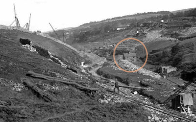
A grainy photo of a building half-way down the Bunsall Incline has always intrigued me. A recently discovered map from around 1855 shows it marked as a cottage, lying opposite a long-lost engine house.
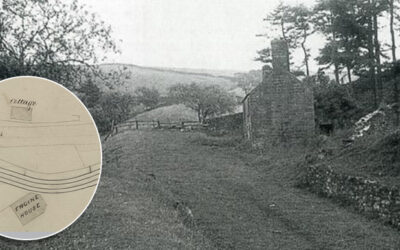
A grainy photo of a building half-way down the Bunsall Incline has always intrigued me. A recently discovered map from around 1855 shows it marked as a cottage, lying opposite a long-lost engine house.
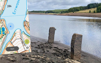
Yet more stone features are appearing above the surface of Errwood Reservoir. The four nearest the bank could have been part of the large twin barns which stood beside the lane to Errwood Hall.
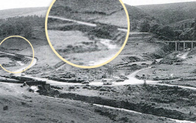
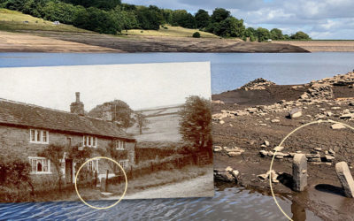
A grainy photo taken shortly before Errwood Reservoir was flooded in 1968 seems to solve the mystery of the sturdy gateposts that have recently surfaced during the drought of August 2022.
The second part of my attempts to trace features that have emerged during the recent drought; a pair of sturdy gateposts and a junction of lanes, all of which have been hidden since Errwood was flooded.
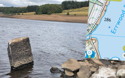
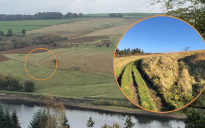
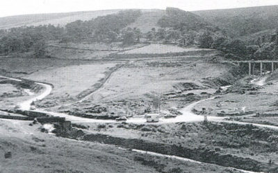
The water level in Errwood Reservoir has dropped significantly over recent weeks, revealing some interesting features from the past. Trying to identify where they once lay is a fascinating challenge.
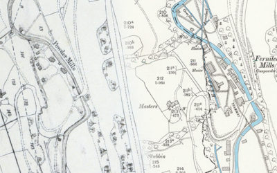
Comparing the recently discovered 1846 plans of the valley with OS maps from the 1890s reveal some fascinating changes, but also poses the question of when Grimshaw turned to Grimshawe.
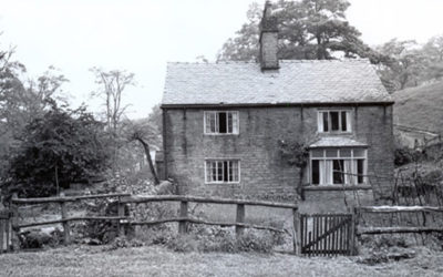
A photo of a derelict building known as Boothman’s Cottages recently came to light. There’s nothing left of it today. Was it connected to coal mining, or simply a stop-off point for weary travellers?
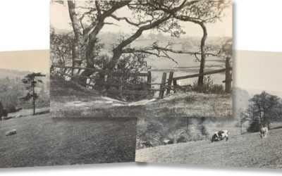
Two bridges – both close to Errwood Hall. One that I’d never seen before, and another which I wasn’t sure ever existed. All it needed to solve the mystery was a pair of wellington boots.
The augmented reality app which will bring the ruins of Errwood Hall to life is still at the planning stage. The first step is to identify the layout of the rooms. Any help would be much appreciated.
I’d always understood that Errwood Hall was used as a Youth Hostel for a couple of years after Mary Grimshawe’s death in 1930. But according to recently discovered YHA records, that’s not correct.
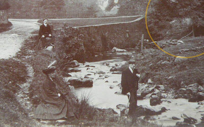
An old postcard recently appeared on ebay captioned ‘Goyt Valley’. But I really struggled to work out where it was taken. Sharper eyes than mine spotted a bridge arch hidden by trees. Mystery solved!
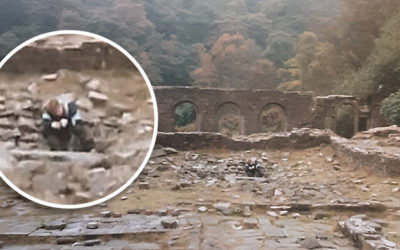
A recently discovered photo taken in 1988 shows a young boy peering into a hole in the centre of the Errwood Hall ruins. I wonder whether it might be the entrance to the cellars.
Three old photos recently popped up on ebay, captioned ‘Goyt Valley 1950s’. But where were they taken, and was the date correct? There’s only one man who knows the answer…
I’ve made a start at adding the final three houses to the the list of those demolished in the 1930s, following the purchase of the Errwood Estate by Stockport Corporation to build the twin reservoirs.
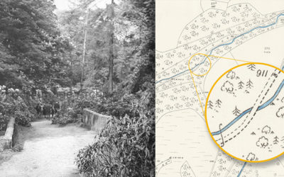
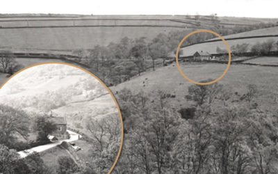
The felling of the fir trees above Fernilee has opened up some wonderful views across the valley. I was curious about some tracks running up from the path along the opposite side of the reservoir.
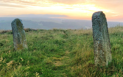
A couple of sturdy stone gateposts near the top of Old Goyt’s Lane once guarded access onto the track of the Bunsall Incline; the steep slope that today forms the main route into the valley.
Two very similar postcard views of Goyts Bridge are probably separated by only a few years, but reveal a massive change in fortunes for this wonderfully scenic spot beside the Goyt.
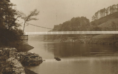
A 1948 article describing a walk through the Goyt Valley, from Whaley Bridge to Buxton, makes fascinating reading. It also reveals that I’d got the position of the suspension bridge completely wrong.
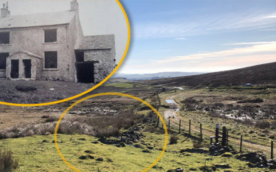
Continuing the hunt to trace the history of some of the stone gateposts that stand around the Goyt Valley – this time to the west of Fernilee Reservoir, on the main track and up to Intake Farm.
I’ve just come across some wonderful photos of the old packhorse bridge on Flickr. I’m not sure when they were taken – perhaps in the ’30s or ’40s. The bridge now spans the Goyt about a mile upstream.
Thanks to Bill and Chris, I’ve managed to pinpoint the house known as The Hollows which featured in the collection of photos taken in the early 1930s, before work started on Fernilee Reservoir.
One of the collection of 1930s photos of the valley had even Bill Brocklehurst stumped. And he’s lived and farmed in the valley virtually all his life. But I think we’re getting closer to identifying it.
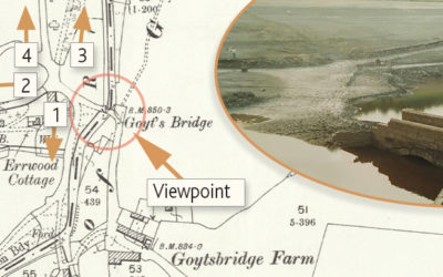
A rare photo of Goyt’s Bridge in 1967, just a few months before this upper part of the valley was flooded. And some views of the same area during the most recent severe drought, in the early 1990s.
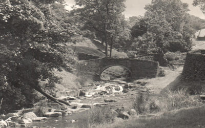
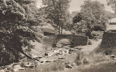
Gary’s photos of Errwood Bridge emerging during the 1984 drought show it had two arches. But all the pre-flood photos I’ve seen only seem to show the one. Bill Brocklehurst solves the mystery.
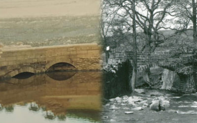
Gary’s photos of Errwood Bridge emerging from the waters of Errwood Reservoir during the drought of 1984 sparked a lot of interest. I’ve included some maps, and a ‘then & now’ fade, to show its position.
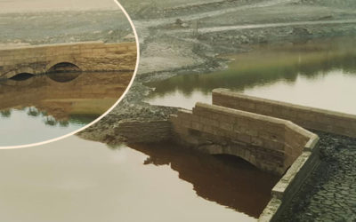
A unique collection of photos show Errwood Bridge emerging from beneath the water during a long dry spell in the autumn of 1984. It was one of two bridges in Goyt’s Bridge. But this wasn’t saved.
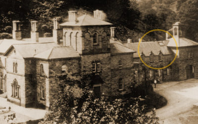
A mystery building alongside The Valentine has even Bill Brocklehurst stumped. And he’s lived and farmed in the Goyt Valley for most of his life. Perhaps it was Mrs Pickup’s shop…
A collection of grainy photos shows the Goyt Valley just before construction work started on Fernilee Reservoir. Help identifying some of the more obscure images would be appreciated!

The arrival of the railways to Buxton in 1863 meant that increasing numbers of visitors could enjoy the tranquil beauty of the Goyt Valley. But it was a story of mixed fortunes for Paxton’s twin stations.
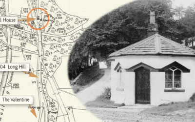
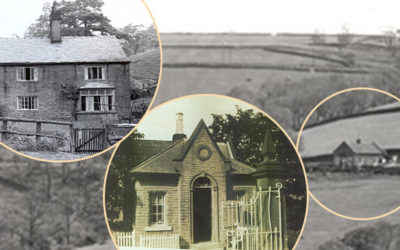
Fernilee Toll House once stood beside the Long Hill Road between Buxton and Whaley Bridge. Today, there’s very little sign this attractive building ever existed. Which is a great shame.