Above: The photo is captioned ‘Bridge Near Errwood Hall: A view of a bridge surrounded by trees with a view of people walking towards the trees. May/June 1964.’
The orange circle shows where it must have crossed Shooter’s Clough, half way along the lane between Errwood Hall and the hamlet of Goyt’s Bridge.
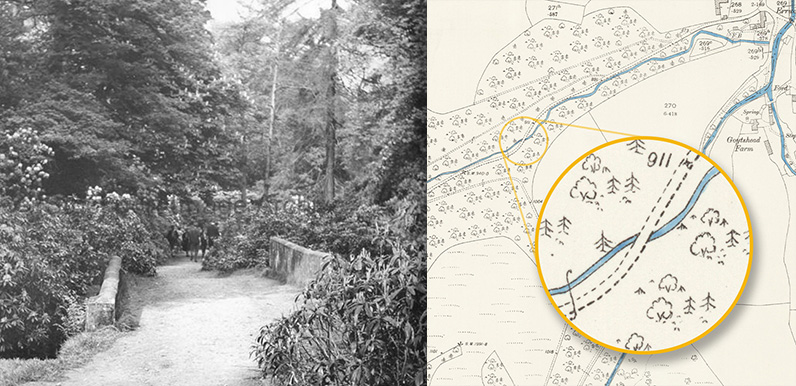
One of the recently discovered photos featured in the previous post intrigued me. It showed what looked like a wide track passing over a bridge. But I couldn’t work out where it could have been taken.
A couple of days ago I was sent a link to Stockport County’s Image Library. Searching through it I came across a few more images that seemed to show the same bridge, with a group of walkers in the distance.
At first I thought it might be close to the ruins of Errwood Hall, where the lane passes over Shooter’s Clough. But a quick visit showed that the sides don’t match up with the stream. There’s also no evidence that this bridge ever had stone sides.
It was James on the Goyt Valley Facebook Group who spotted another bridge on an old map (top of page), further along the lane towards Goyt’s Bridge. And a quick check showed that this must be the one in the photo.
The sides of the bridge align with the angle of Shooter’s Clough, with the nearer one closer to the camera. Unlike the other bridge where the side on the left would have been further away. So one mystery solved!

Another bridge mystery…
There’s another bridge marked on old maps of Errwood Hall that I’ve always found a mystery. It seems to cross over from the hall to the other side of a fairly steep gorge, and then along a path that runs to the north of Shooter’s Clough.
But I’ve never seen any mention of it in any contemporary reports, and the 50-60 foot drop down to the stream looks far too steep to safely descend (below). There’s also no sign of any path on the other side of the stream.

So when I investigated the nearby bridge to see if it could have been the one in the top photo, I thought I’d don my wellies and take a closer look. And I found the evidence I was searching for, including stone sections of both bridge supports, plus a fairly large chunk of what looks like early reinforced concrete.
I could also see that the path down didn’t look quite as treacherous as it did from the top – although I’m sure it would have needed some kind of safety railing to prevent accidents.
Simply click on any of the images below to enlarge and scroll through them. The path on the other side is completely overgrown with rhododendron and impossible to explore. But it must meet up with the path that bridges Shooter’s Clough described in the first part of this post.
Above: Click on either button – or drag the green slider – to view then and now images showing the position of the hall and bridge.
I’ve also circled in darker brown a small area of stone walling that was uncovered when the rhododendrons were removed a couple of years ago (pic below). This looks like it may have bordered the path running down the gorge to the bridge and is a good indicator for where the track once lay.


Page update: 25.8.22: Many thanks to Rod from the Goyt Valley Facebook Group for sending this photo taken along the old drive between Goyt’s Bridge and Errwood Hall during the drought of August 2022. (See his comment below.)

I’ve often wondered if the bridge, or its remains, shown in the ‘Bridge Near Errwood Hall’ shot are still evident when the water levels of the reservoir drop. The valley in that area is overgrown with vegetation so it is not easy to inspect the locality. However, with the recent drop in water level I decided to inspect the old driveway from the Hall end to see if anything could be found.
After battling my way along the road and fighting my through the thick vegetation I came across some pitching stones that I believe formed part of the old bridge structure. These would have been under the bridge arch and would have provided protection to the bridge supports.
As it happens I discovered these remains about 30m before the vegetation ends and the new bridge comes into view. Consequently, with the water level being so low, the ruins are much more easily accessed from the new bridge end. So although the bridge is no longer there, its location can be identified. If it is of any interest I can provide photos of the remains.