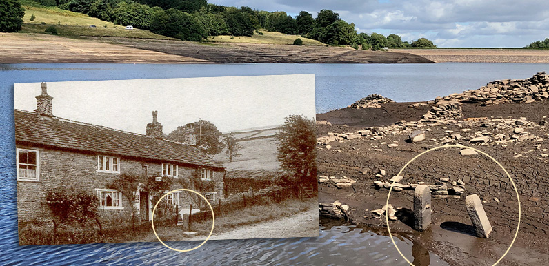
Above: These twin stone gateposts once stood either side of the entrance to Goytsbridge Farm.
Anyone who has visited the valley over recent weeks will have seen that the water level in Errwood Reservoir has dropped very low. And it’s revealed some fascinating objects from the past.
Errwood was flooded in 1968, some 30 years after Fernilee to the north. The hamlet of Goyt’s Bridge once lay at the southern end of the reservoir, opposite the modern metal bridge. Most of the buildings were demolished in the 1930s, soon after Stockport Corporation purchased the estate to build the twin reservoirs. The only buildings to survive were two bridges.
The older packhorse bridge was rebuilt further upstream at Goytsclough (click to view). Stockport Corporation attempted to sell the larger Errwood Bridge but there were no takers and it sank below the waters. The last time it emerged was in 1984 (click to view). But at the rate the water level is dropping, it may soon reappear. I’ve shown its position on the fade below.
I’ve taken a few photos to try and identify where some of the objects which have surfaced once lay in the landscape. These include the old road as well as a number of stone walls and gateposts. Chris (my co-admin on the Goyt Valley Facebook Group) identified two stone posts near the waters edge at the southeast as belonging to Goytsbridge Farm (see top photos).

Above: the chef and two of his waitresses pictured standing at the entrance to the farmhouse, behind the twin gateposts.
It was one of two farms in Goyt’s Bridge, both of which served teas to the many visitors who flocked to this picturesque spot following the arrival of the railways to Buxton in the 1860s.

Mark posted this aerial view taken from a drone a few days ago on the Facebook Group showing the foundations of a building close to the gateposts, and a stretch of stone wall disappearing into the water.
I’m not 100% sure because I don’t know which way is north, but I think this was a large barn which once belonged to Goytshead Farm. (Mark is going to try and take some more drone photos to confirm its exact position.)

I’ve circled it on one of my favourite illustrations of Goyt’s Bridge, which features on the cover of Gerald Hancock’s wonderful little book, Goyt Valley Romance.
I’ve marked both the barn and the gateposts on the fade above. Simply click the ‘Now’ button to reveal a satellite view of the reservoir today. It shows just how far the water level has dropped over recent weeks.
I’ll follow up this post with others showing yet more features which once lay under the waters of the reservoir and have recently emerged above the surface.

Page update: Many thanks to Nick from the Facebook Group for posting this drone photo showing both the gateposts (circled at bottom) and the barn foundations (at top).
It provides enough information to reveal that the foundations were southwest of the gateposts, and so must have been the large barn at Goytshead Farm circled in the old illustration.
