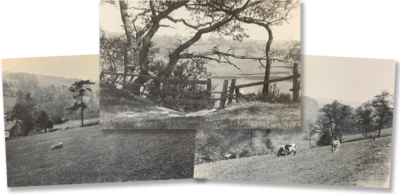
Above: These three photos recently popped up on ebay, captioned ‘Goyt Valley 1950s’.
Ebay is a great source for old postcards of the Goyt Valley. They pop up fairly regularly. But I’ve seen most of them before. These three were different as they’re personal photos rather than commercial postcards. They were marked Goyt Valley 1950s, but I think they may have been taken much earlier.
I started this website after Gerald Hancock let me scan his collection of old images he’d discovered researching his Goyt Valley Romance book. I found it fascinating trying to place the various scenes and buildings from before the construction of the twin reservoirs.
Many of them weren’t easy to locate, and I relied on Bill Brocklehurst to point me in the right direction. Bill has lived and farmed in the valley for most of his life and can identify places simply by field boundaries, and the shapes of woods and far horizons.
The orange arrows on the early 1900s maps show where Bill thinks the photos were taken. I’ve superimposed the reservoirs on top to give an idea of the landscape today. (Click any map to enlarge.)


There’s an evocative interview here with the last farmer at Bunsal, Joe Hibbert, and his wife Prudence, recorded in 1936. (And click here for more information about Bunsal Farm.)


This photo was more difficult to place. Bill said: “It’s Intake Pastures looking across at Nook Wood” (click to enlarge). Which I think means it’s taken from close to Intake Farm, on the western side of the valley, looking southeast across towards Nook Farm.
So it would be the old C&HPR track running across the centre of the photo, with the Buxton to Whaley Bridge Long Hill road above. This would confirm that the photos were taken before the construction of Fernilee Reservoir in the early 1930s, as this section of the valley would have been flooded well before the 1950s.


This is my favourite of the three photos. I thought it might be a stile that once led to a small ford across the valley, which was later replaced with the suspension bridge over Fernilee Reservoir. But Bill said: “It’s at the bottom end of Hillbridge Wharf”.
So today, this stile would lead down to the narrow concrete and steel footbridge that crosses the Goyt between Fernilee Reservoir and Taxal (see point 8 on this walk).

Loved these new photos particularly Intake Pastures. Intake Farm was farmed by my late husband’s ancestors so was thrilled to see these photos. It would be nice to see a photo of Intake farm itself one day. Thank you for creating this wonderful website, David.