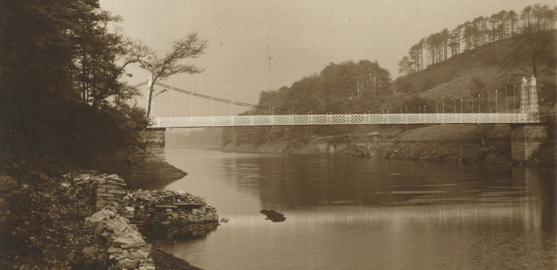
Above: The attractive suspension bridge was built at the same time as the reservoir, to enable locals to walk from one side to the other.

Above: Sharon posted this photo of her Great Aunt May posing on the bridge on the Goyt Valley Facebook page.
Gail recently sent me an article she discovered in the archives describing a walk through the Goyt Valley, from Whaley Bridge to Buxton, that appeared in the August 7th 1948 edition of the Manchester Evening News.
It was headlined ‘Laughing water’ and written under the pseudonym Perigarth. This was after the construction of Fernilee Reservoir (1937), but before Errwood (1968), so I was interested to see if I could work out the route from the fairly basic map (below).
It followed the western side of Fernilee as far as the suspension bridge, and then offered a choice of ways to reach Buxton. It’s the first time I’ve seen the bridge mentioned in a walk. And looking at the old OS maps of this period, it made me realise I’d been wrong in where it was positioned (see fade under the article).

Laughing water
People will always be attracted to the Goyt Valley, which has seen many changes since 1848. A railway has been discarded that formerly ran through the valley, and ramblers now use the old track.
More recently Stockport Corporation have built a reservoir – when the level is high a lovely expanse of water sparkling in sun or sullen in cloud, but always silent and aloof in contrast to the river, formerly gay and boisterous, as it still is above the reservoir.
Beginning at Whaley Bridge turn right under the railway bridge and in half a mile cross a footbridge and the embankment of Todd Brook Reservoir. (If you’ve either a pram or bike with you turn in by a little chapel 100 yards short of the embankment, otherwise you’re liable to a 40s fine – a restriction on crossing the embankment that ought to be removed forthwith.)
Turn right when over the reservoir, proceed round by Reddish Lane to and across Macclesfield Road, then by an ash, birch, white-thorn, sycamore, and oak – fringed lane, and soon bear right by a path to Taxal.
Goyt’s arresting musician
Continue in front of the lodge gates and by a pair of weeping poplars to a dell of tall oaks and beeches that have happily escaped the axe, whence you may enjoy the murmuring Goyt’s arresting musician on a still and sultry afternoon.
Beyond Taxal Church a lane takes you to a wide pasture, and in a few yards a path bearing left diagonally to a ruined farmstead leads to a stile and a woodland walk by the river.
Where the path divides do not cross but keep along the right of the Goyt, mount the hill, go through the farmyard at the top, and turn left into a track by the right of a wall, which later proceeds along the right of the reservoir, and at an old gateway you descend by a path to the water’s edge and continue along the right bank.
At the suspension bridge there are alternatives:
(a) To cross the reservoir, and at an old railway bridge looking like a hole in the hillside join the old railway. If you choose this way keep along to the tunnel, the return left by a stile leading along a path ending in a lane, where turn right to Burbage and Buxton.
(b) To continue up the valley to and beyond Goyt’s Bridge by the road the right of the river through the wood. A mile beyond the woodland a path (left) descends to the stream.
You cross and proceed uptake Clough to the head, where the path swings right over the stream, and in another mile re4aches an old road. A further two miles along the road brings you to Buxton.
Distance by (a) 11 miles; (b) 12 miles. Which is preferable? I like (a) for vistas of the lower valley and (b) for intimacy of woodland, heather, and bracken-clothed moors.
More on the the suspension bridge…
This page includes more information and photos of the bridge.
This page includes a fade showing where I thought the bridge was positioned.
There’s an aerial view of the bridge on this page.
