Above: Boothman’s Cottages would have been a bleak place to live in winter. But well-placed to pick up custom from the many travellers who passed this way.

Above: An old photo showing the remains of the engine house (click to enlarge). There’s nothing now left to see.
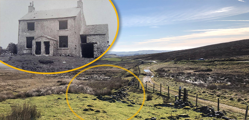
I’ve often wondered about a couple of buildings shown on old OS maps that have vanished from the landscape, about half-a-mile east of Derbyshire Bridge car park; Boothman’s Cottages and an engine house.
The engine house would have been part of the coal workings which pepper this bleak and windswept moorland. And could have been used to pump water from the mines, or lift coal to the surface – or perhaps both. But I wasn’t sure about the cottages.
A mine manager called Boothman appears in the old records, so this might be an obvious connection to the mines. But the building was also known as ‘half-way cottages’ because they lay close to the new Buxton to Macclesfield turnpike (the present A537), about half-way between Buxton and the Cat and Fiddle.

Above: I’m not sure when this photo of Boothman’s Cottages was taken. I think it was abandoned around 1910, so possibly in the 1920s.
When I asked whether anyone on the Goyt Valley Facebook Group knew anything about the cottages, Martin posted the above photo which belonged to his aunt. She’d written:
“Jess and Edith Grindy lived there in the late 1800s, early 1900s. His grandmother sold goats milk to the coach travellers and his grandfather was a horse Ostler who changed the horses which had travelled from Macclesfield or Buxton up and down the steep hills to the Cat & Fiddle and were exhausted.”
Grindy is mentioned in a 1946 article by GHB Ward, one of the founders of the Ramblers (click here to read the article in full*);
Mr Jessie Grindy (aged 64) of Chapel Row, Ladmanlow, says he left Moss Hall Farm House about 1932, and the old natives do not forget they were turned out, and the four houses afterwards erased, except for Goyts Moss Farm now (Dec. 1943) – windowless and doorless and partially roofless, because Stockport Corporation had obtained the land and were making Fernilee Reservoir, about 2.5 miles away. Some day the making of desert land around a reservoir will be sternly prohibited.
*Many thanks to Alison Broady for transcribing the article.
Above: This early 1900s map shows both the cottages and the engine house but there’s nothing left on the ground today. Click the Now button – or drag the green slider – to see a satellite image of the same area which reveals some of the many coal pits.

Above: The main coal fields lay between Buxton and Goyt’s Moss (click to enlarge). The white rectangle shows the same area as the fade.
Coal had been mined here for many centuries, simply by digging pits from the surface. But by the 1700s the miners had been forced to go deeper, which increased the risk of flooding.
Two tunnels – also known as adits or levels – were mined to access the coal at greater depths and provide drainage, using both boats and small steam engines, all the way from the outskirts of Buxton – a distance of some 1.5 miles. Duke’s Level was completed in around 1770, and Goyt New Tunnel in 1812.
I’ve marked these tunnels in red on the satellite image, and based them on diagrams in Alan Robert’s book, ‘The Coal Mines of Buxton’. The route of the Duke’s Level passed close to the cottages and Alan thinks they would have been built for mine workers and their families.
It would have been a harsh existence and selling food and services to passers-by would have supplemented their meagre wages. The mines closed in 1893, but the Grindys could have earned a living for a few more years until they moved on to Moss Hall Farm House. Where they remained until Stockport Corporation purchased the Errwood Estate and they were forced to move on once again.
Page update 1: Alan Roberts has been in touch to clarify details on the roads in the area. He writes:
The situation regarding the roads is a bit more complicated than you have described. Here’s a summary:
1759: Buxton to Macc turnpike (TP) now Macc Old Road.
1765: Buxton to Leek TP from Axe Edge down to Green Lane in Buxton.
1773: Branch of Leek/Buxton TP from Ladmanlow to the Goyt Valley, between Terret/Ladmans Low and Axe Edge, descending to the valley and crossing to the pits up a steep slope.
1789: TP from Congleton to join the Leek/Buxton TP branch on Thatch Moss (a deviation on Axe Edge was later added to ease the gradient up from Ladmanlow).
1820: New TP Macc to Buxton, crossing Congleton TP which then ends at the new TP, a small reduction in length.The effect of all this is that Boothman’s Cottages are located at the 1789 junction of the Leek/Buxton TP branch to the coalfields and the Congleton TP which is why they are a short distance from the Macclesfield new road. All of the above routes are still shown as tracks on the late 19th century OS 6inch maps.
Page update 2: William Grindey got in touch via the GV Facebook Group to say: “When I was living in Burbage in the 1950 we always called it the half way house. My second cousin was the last to inhabit the house in the late 40s, early 50s. My mother used to say Lord Derby’s gamekeeper lived in it for many years, before the war.”
Jacqui Owens also remembers it in the late 50s, early 60s. So perhaps I was wrong in thinking it had been demolished in the 1920s. Although the photo does look like it was taken at that time. And if you visit the site, there’s very little to see, apart from a level area of ground and a few scattered stones, under a thick carpet of vegetation.
