Above: A grainy black and white photo of the area soon to be flooded under Errwood Reservoir reveals clues to the purpose of the recently exposed gateposts.
I think I’ve solved the mystery of the twin gateposts featured in the previous post. They’ve recently risen above the surface of Errwood Reservoir during this August’s drought. But since they’re not on the border of any field, and just a short distance away from the River Goyt down a fairly steep drop, I couldn’t work out why they were there.
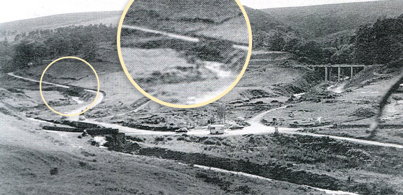
I was looking at an old photo taken just before the reservoir was flooded in 1968 for clues. I noticed a shape which I thought could be the short stretch of stone walling that’s appeared further down the slope from the posts and is still only a few inches above the surface. I think it must have supported the road where it came closest to the river.

Above: A photo of the walling taken from a drone, looking back up the road from Goyt’s Bridge to Goytsclough with the gateposts circled. (Thanks to Nick.)
The old black and white photo appeared in a book from the 1960s and has a fairly course screen so isn’t that sharp, but I’m fairly confident that I’ve circled the wall. Just beyond it are what could be the twin gateposts. And it looks like there could be a man-made ramp from the gates down to the Goyt.
The fields on the other side of the river belonged to Goytshead Farm. Bridges and fords are normally marked on the old maps. But the Goyt was little more than a stream at this point. So I’m fairly sure that cattle would have been able to cross over without great difficulty.
Click the ‘Now’ button to see my attempts at matching the 1960s view with the same scene today. It’s not perfect since the original was taken a short distance further down the slope and I didn’t fancy drowning! But it lines up fairly closely.
I’ve highlighted the wall and gateposts on this map dating from the 1890s, as well as the camera angle of the ’60s photo. Clicking the Now button, or dragging the slider, shows how far the water level in Errwood Reservoir has dropped over recent weeks to expose the posts and wall.
It’s still got some way to go before Errwood Bridge appears. Click here to view photos of the last time it surfaced, back in August 1984.

Page update: 29.8.22: Many thanks to Chris on the Goyt Valley Facebook Group for posting this photo showing both the gateposts and the short stretch of wall (click to enlarge).
I thought the slope running down to the Goyt might have been man-made but this image reveals that was simply a track running down the side of the river bank. I’m not sure when the image was taken, but it doesn’t look like there was a gate across the posts at this time.

This is another of Chris’s photos posted on the FB Group. I think it must be the drought of 1984 and shows the short stretch of wall at bottom right, and Errwood Bridge in the centre.
The water level seems to have stopped dropping over recent days, which is a good thing. But I think it means we won’t see the bridge resurfacing – which is a shame as a few of us were planning to hold a party on it!
