Three ‘then and now’ fades show a more positive side to Taxal’s Rev Evans, including the installation of six new and recast bells, the rebuilding of the chancel, and the expansion of the graveyard.
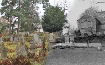
Three ‘then and now’ fades show a more positive side to Taxal’s Rev Evans, including the installation of six new and recast bells, the rebuilding of the chancel, and the expansion of the graveyard.
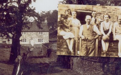
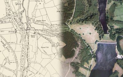
Thanks to Bill and Chris, I’ve managed to pinpoint the house known as The Hollows which featured in the collection of photos taken in the early 1930s, before work started on Fernilee Reservoir.
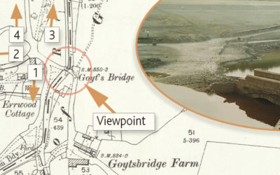
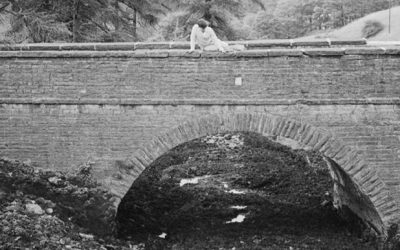
Gary’s photos of Errwood Bridge emerging from the waters of Errwood Reservoir during the drought of 1984 sparked a lot of interest. I’ve included some maps, and a ‘then & now’ fade, to show its position.
A mystery building alongside The Valentine has even Bill Brocklehurst stumped. And he’s lived and farmed in the Goyt Valley for most of his life. Perhaps it was Mrs Pickup’s shop…

The arrival of the railways to Buxton in 1863 meant that increasing numbers of visitors could enjoy the tranquil beauty of the Goyt Valley. But it was a story of mixed fortunes for Paxton’s twin stations.
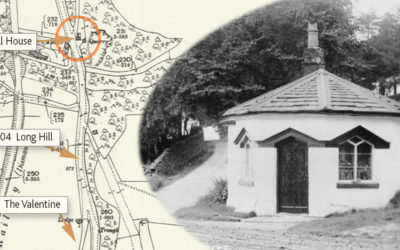
Fernilee Toll House once stood beside the Long Hill Road between Buxton and Whaley Bridge. Today, there’s very little sign this attractive building ever existed. Which is a great shame.
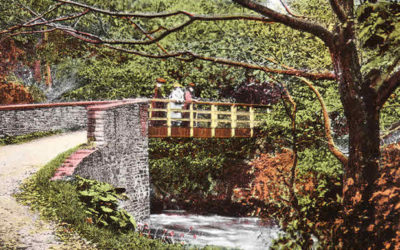
A photo captioned ‘View of footbridge over stream (possibly Goyt Valley) c.1854’ was a fascinating find. But identifying where it once stood wasn’t so easy. Could it have been the one over the Goyt at Taxal?
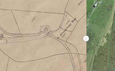
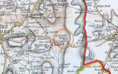
Alec has discovered a wonderful website that reveals a lot about the history of the Cheshire side of the Goyt Valley. Including the position of the second Stonyway Toll House.
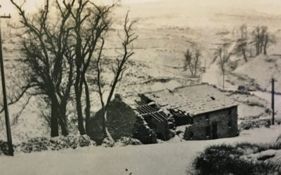
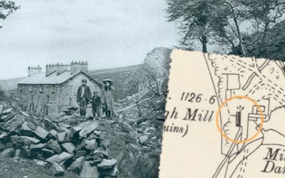
Another photo from the 1960s album shows Goyt’s Moss Farm in ruins. Which is odd as that this would mean it had been derelict for some 30 years. Perhaps the photo is earlier than I thought.
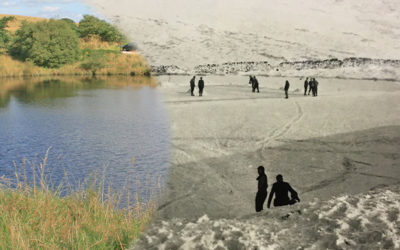
An early ’60s black and white photo of skaters on the frozen pond at the head of the Bunsall Incline brings back memories of an earlier scene, described in Strephon’s typically flowery style in an 1880 article.
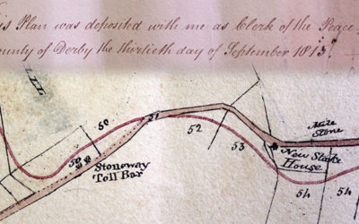
After much discussion on the Goyt Valley Facebook Group, we think we’ve finally nailed down where the first Stonyway Toll Booth once stood. But where it was moved to is still a mystery!
This toll booth was one of five on the first Buxton to Macclesfield turnpike, forcing poorly-paid locals to pay a small tax for passing through the gates. Unsurprisingly, they were highly unpopular.
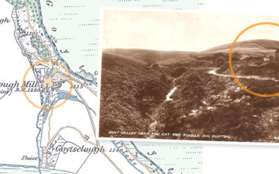
A signpost beside the Cat & Fiddle points towards Derbyshire Bridge at the southern end of the Goyt Valley. But this is Goyt’s Moss. And the bridge is further along the road towards the twin reservoirs.
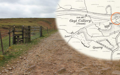
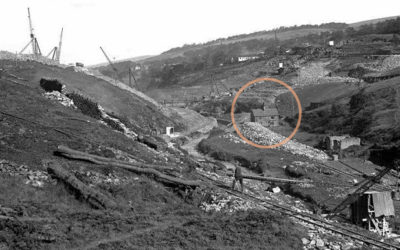
An old OS map reveals a wealth of fascinating detail on what was once a busy colliery on the outskirts of Buxton, where coal was unloaded from tunnels extending as far as Goyt’s Moss, over a mile away.
A writer in 1810 describes an ancient settlement close to Withinleach Farm. Today the farm is just a pile of stones beside the path to St. Joseph’s Shrine. It’s yet another Goyt Valley mystery.
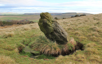
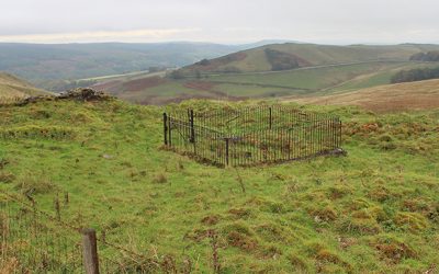
Could a small circle of jumbled stones mark a Bronze Age burial? And might a small standing stone be an ancient waymarker that once guided travellers across this windswept landscape?
A 1997 archeological survey traced the history of coal mining at Goyt’s Moss, from surface workings dating back to the early 1700s to deeper shafts using horses to winch coal up from the seam.
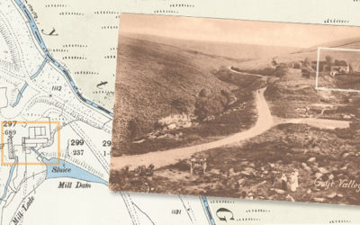
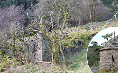
An even older photo of Goytsclough shows the paint mill ruins in greater detail. It hopefully brings me one step closer to discovering where the giant waterwheel once stood.
An old postcard of Goytsclough provides another small but tantalising clue in the puzzle over the giant waterwheel that once powered both the stone quarry and the later paint mill.
A new ‘then & now’ fade of one of my favourite old photos of the valley helps pinpoint exactly where the cottages at Goytsclough once stood. And it’s not where I thought!
Don asks about the foundations which lie just over the fence, coming down from the Long Hill road towards the Goyt Valley. I wonder whether it may once have been a toll house. But who knows?
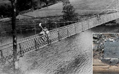
Another of my theories bites the dust! I was sure the brick pillar that surfaced during this summer must have been one of the supports for the suspension bridge. But it appears not.
A new ‘then and now’ fade features one of my favourite photos of the Goyt Valley; Kathleen Nall collecting water at the natural spring outside her family home, Castedge Farm Cottage.
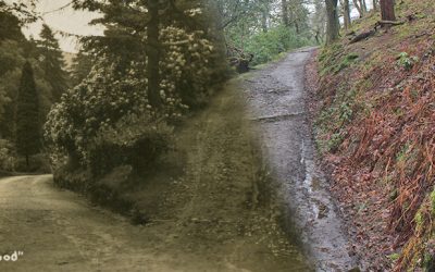
In 1880 a writer described “a footpath high above the carriage-way… a lovers’ walk; a deep-green wooded way made for Phillida and Corydon”. My thanks to James for pointing me in the right direction.
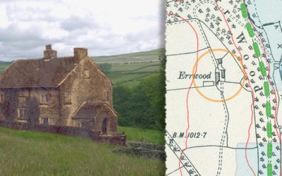
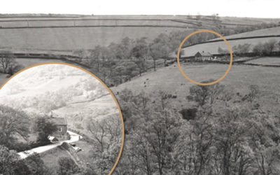
Samuel Grimshawe stayed at Errwood Farm to oversee the construction of Errwood Hall in the 1830s. This composite image shows the attractive farmhouse in today’s landscape.
From Derbyshire Bridge in the south to Taxal in the north, this series of ‘then & now’ fades show how the Goyt Valley has changed since the construction of the twin reservoirs.
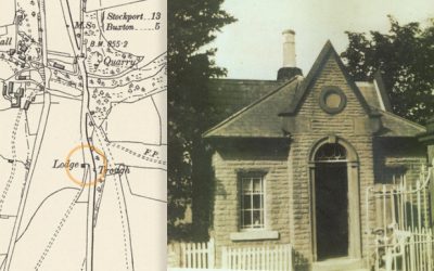
Gerald Hancock wrote ‘The Lodge’ on the back of this photo. But I’ve never been able to pinpoint where it was located. Could a lodge marked on an 1888 map of Fernilee provide the answer?
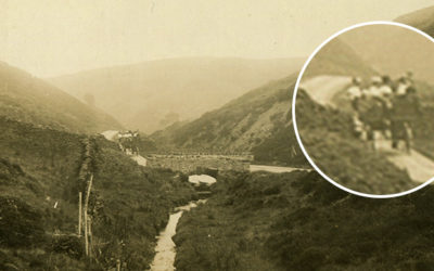
A recently discovered photo shows the bridge over the Bunsal Incline on the C&HP Railway in the late 1960s, shortly before the track was tarmacked to create the main route into the valley.
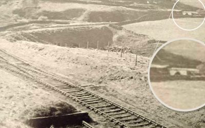
Trying to pinpoint the position of a section the C&HP Railway shown in an old photo posed a bit of a mystery. We think it might show a rare view of the track as it heads towards the valley.

The Forestry Commission is clearing a lot of the rhododendrons from the valley. They say they’re both invasive and diseased. I just hope they don’t clear too many as I love to see them in full bloom.