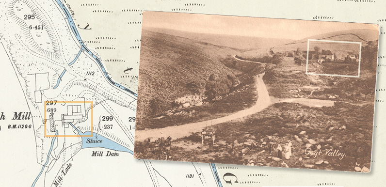
Above: The photo was taken from the slopes surrounding Goytsclough Quarry, looking south along the road to Derbyshire Bridge.
The River Goyt runs along the valley to the left. A mill lade flowing from the river along the hillside supplied water to the giant waterwheel.
I’ve taken a second look at one of my old postcards of Goytsclough and realised it provides a far better view of the paint mill ruins than the one featured in the previous post. I’ve also found an old map which shows the buildings in more detail.
It’s still not possible to pinpoint exactly where the giant waterwheel once stood, but I think I’m narrowing down the options.
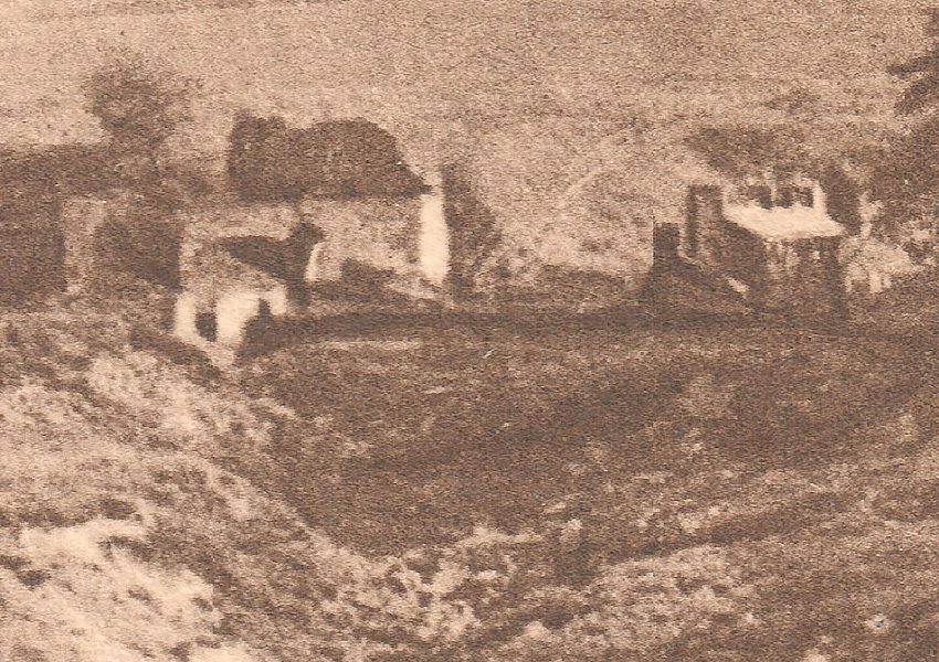
Above: I’ve zoomed in as close as possible into the ruins, and added a sharpen filter to provide a bit more contrast (click to enlarge).
The building on the right was known as Goytsclough Mill Cottages. These survived until Stockport Corporation purchased the estate in 1930 to construct the twin reservoirs. The buildings on the left are the remains of Goytsclough Paint Mill, which once housed the waterwheel.
According to Gerald Hancock in his ‘Goyt Valley Romance’, the mill closed in 1890. I would guess the photo was taken in the late 1890s – perhaps the early 1900s.
We know from an 1857 newspaper report (click to view) that the 36ft diameter waterwheel had been left to rot and rust ‘for many years’ following the closure of Goytsclough Quarry. But that it had been recently renovated for use in the newly-opened paint mill.
I’m still trying to work out where the giant waterwheel once stood. And how the various streams, sluices, mill lades and mill ponds powered the wheel. This fade shows a map from the early 1890s and the scene today. And also the viewpoint of the photo.
I’m always impressed by how accurate these late Victorian maps were. But there are a few features that were either wrongly plotted, or have changed position over the years. And the most obvious is the path of Deep Clough stream which runs from south to north, before flowing into the Goyt.
It clearly goes underground for a short distance, from just beside the cottages. But this southern section seems to have once been diverted further to the east – maybe during the construction of the various buildings. Perhaps the stream was allowed to follow its original course after the demolition of the cottages in the mid 1930s.
Click here to view side-by-side images of both the 1890s map and a satellite image in more detail.
Page update: 4th December 2020
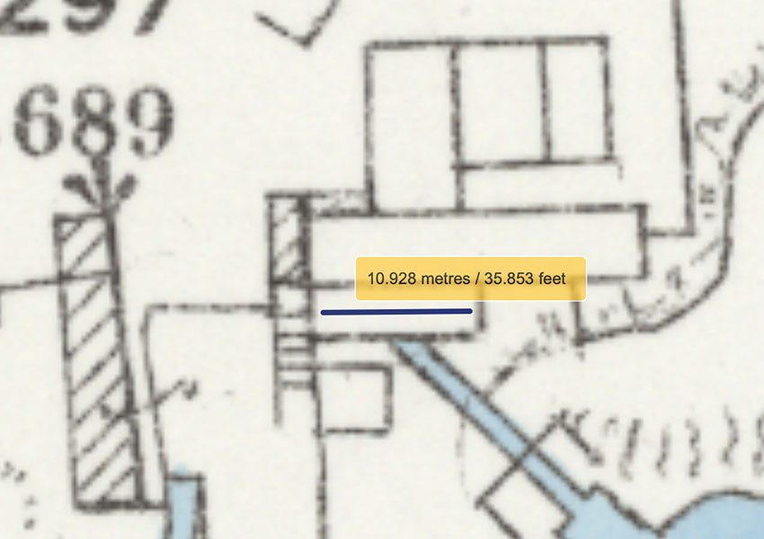
I just discovered a way to measure distances using the website that matches old maps with satellite images. And hey-presto, it appears that the waterwheel – which we know from the 1857 newspaper report was 36 feet in diameter – fits exactly within the space beneath the water feed from the mill pond.
I think it must now be safe to say this is where the waterwheel was housed. Or perhaps this rectangle may even represent the wheel. It also looks as though there may be a series of steps on the left which would have led from the foot of the wheel up to the millpond.
When Clifford Rathbone wrote about his 1950s walk through the Goyt Valley, he mentioned something his 76-year-old companion told him about the waterwheel:
She could not remember the mill being worked, but she recalled the many occasions she had climbed the stone steps – which are still there – to watch the waterwheel.
Maybe these are the same steps she once climbed as a young child at the end of the 19th century.

Page update: 24th April 2022
My thanks to Frank Hambleton for allowing me to copy this photo from his ‘Buxton Spatown & District Photographs’ Facebook Group (click to enlarge). I’m not 100% sure, but there seems to be a faint circle where the paint mill stood which may be the waterwheel. I’d love to find a higher resolution version of the photo that might confirm things. I’ll update this page if I ever manage to locate one.

Page update: 25th April 2022
Chris has spotted what looks to be the waterwheel standing beside the road to Derbyshire Bridge. Which is a bit of a mystery as it’s definitely not where it’s shown on the maps. If it is the wheel, I’m wondering whether it might have been rolled down to that point for dismantling. Or perhaps I’m completely wrong and this is where it was always situated!
