Above: The orange circle above left shows the track leading down to the stepping stones from behind Goytshead Farm.
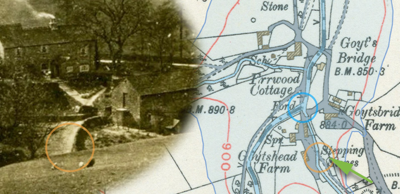
I’ve also circled both sets of stepping stones on the old map of Goyt’s Bridge – the main ones over the Goyt in blue, and the second set in orange.
A recently discovered photo of Goytshead Farm (see previous post) comes frustratingly close to revealing a feature marked on old maps that I’ve never seen; a second set of stepping stones that lay just a short distance south of the packhorse bridge.
The photograph was taken by Alfreda Attrill, a Canadian nurse who was visiting Goyt’s Bridge during a break from her duties tending injured WW1 soldiers at a Buxton hospital in 1918. I’ve marked where I think she must have been standing with a green arrow – on Goyt’s Lane as it snaked down from Long Hill towards the hamlet.
There are many photos of the main stepping stones over the Goyt (click to view). This second set would have been far less well used, and may have been part of an ancient packhorse route, heading alongside Wildmoorestone Brook towards Burbage on the southern outskirts of Buxton.

I’ve highlighted the track running down from the stepping stones in orange. (Walk 27 follows much of this route as it leads up to the tunnel on the Cromford & High Peak Railway.)
The old railway track is marked in brown (this part of the line was abandoned in 1892). And Goyt’s Lane in red (this was the main route into Goyt’s Bridge from Buxton and the Long Hill road).
Goyt’s Bridge had been an important crossing point over the Goyt since ancient times, with goods being carried by traders and packhorses to all points of the compass. This route may have provided a useful short cut for travellers heading east and not needing to visit Buxton.
Page update: Click here to read how I found the path leading from the second stepping stones.
