Above: The packhorse bridge with the stepping stones just visible over the Goyt after the surrounding farm houses and barns had been demolished, probably taken in the 1940s.
The bridge would be saved and rebuilt further upstream in 1965, just before this part of the valley was flooded. (Click for more on the bridge.)
The final part of Crichton Porteous’s chapter headed ‘Goyt Recollections’ taken from his popular 1954 book, ‘Peakland’. Click the links at the bottom of the page for the previous two posts. (The text is Crichton’s but the photos and captions are mine.)
After Errwood Hall was abandoned the massed rhododendrons and azaleas became a breeding stronghold of hill foxes, and for many years the keeper from White Hall organised an annual shoot there.
Farmers with guns from neighbouring valleys would stand in line across the top of the glen, and men and youths without guns would beat up towards them.
It was job remembered, pushing through the undergrowth so as not to miss anything, for the rhododendron stems were inextricably tangled and as tough as wire. Sometimes, however, five or six foxes were shot.
The last year before the second war a dozen beagles belonging to the High Peak Hunt were used in place of men beaters, but only one fox was put out, a vixen, though.

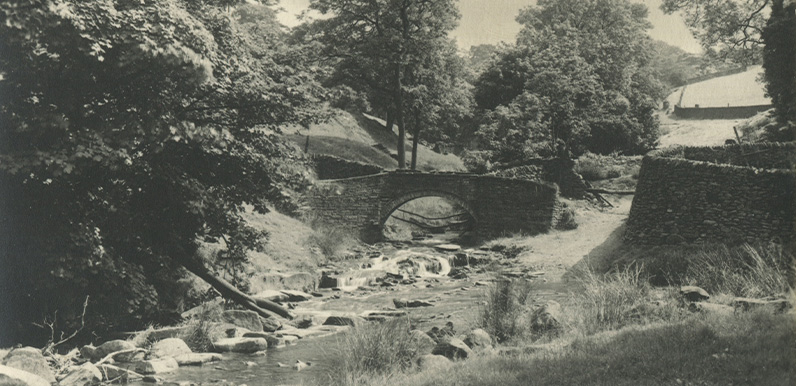
Above: A well-dressed family cross the stepping stones towards the packhorse bridge, possibly to take tea in the garden of Goytshead Farm which is just out of frame to the right. The photo dates to around 1930; not long before the buildings were demolished.
Goyt’s Bridge without its cottages seems a sad place now for all its remaining beauty. The stepping stones even appear to be gradually disappearing; the pack-horse bridge close by spanning the tributary off Burbage Edge is in much better condition.
After coming down the old track off Long Hill, the pack-horses turned sharp right on the lower side of the bridge and went through a ford across the much wider Goyt. One track then, I surmise, as already said, went up Stake Side, and another followed “the Street” up to Jenkins Chapel and on to Saltersford.
Probably this was the main route by which salt was brought in the Middle Ages from Cheshire into Derbyshire. Motorists who do not care to retrace the route by the upper Goyt must leave the Goyt by this Saltersford lane and will soon come to Jenkins Chapel. It somewhat resembles a barn, but has been a place of worship about 250 years.
Walkers can go on from Goyt’s Bridge beside the river by crossing the stile to the left of the railed-up gateway opposite the entrance to Errwood. They then follow the old carriageway of the Grimshawes. Soon the river sounds on the right die out as the current loses itself in the deeper water of Fernilee Reservoir.

Above: The suspension bridge over Fernilee Reservoir was demolished in the 1960s, during the construction of Errwood Reservoir. The road between the two reservoirs meant there was no longer any need for it. (Click here for more info.)
Near the head of the reservoir a steel suspension bridge, connecting as it seems no special place to anywhere else, spans the water, offering a good view northward of the wider end of the reservoir. Erected in 1935 at a cost of well over £500, this bridge is scarcely used in the week.
When Stockport Corporation secured powers in 1929 to build two reservoirs (one still to be made sometime, the dam above Goyt’s Bridge), the Act of Parliament stated that any public paths interfered with should be replaced by others, and this bridge takes the place of an old ford across the Goyt.
A few yards farther down the reservoir, on the east, are the remains of Bunsall Farm, at the foot of the old Bunsall Incline of the Cromford and High Peak Railway. It was here that two boys at play took the brake off a standing railway wagon. Apparently trying to stop it, one of the boys was cut in two.
The old track – still with a few sleepers remaining here and there – follows the east side of the reservoir, though when the railway was in use there was, of course, no reservoir, and the trains ran high along the hillside.

Above: A view looking down the Bunsall Incline before it was tarmacked in 1967. Today it forms the main entrance to the Goyt Valley from the Long Hill road. (Click for more on the C&HP Railway.)

Above: The only photo I’ve managed to find showing Fernilee Gunpowder Mill in full production. It was granted a license 1801 (which means Crichton was wrong when he said it dated back to the 16th century) and closed in 1920. Photo courtesy of Joyce Winfield. (Click for more on the mill.)
Halfway along the reservoir on the west side the old Errwood carriageway disappears underwater, and in the old days crossed the river just above an ancient powder mill, now drowned. It is believed that gunpowder was made there for English ships that fought the Spanish Armada in 1588; the last powder was used in the I914-18 war.
Fernilee Dam provides fine views north and south. It is 130 feet high, and holds back approximately 1,100,000,000 gallons to supply some 250,000 households fourteen miles away in an area covering II0 square miles. Those who still regret the making of the reservoir should remember these facts.
The buildings below the dam are unobtrusive. The Mayor of Stockport, turning the wheel that let the first trickle of water through in June 1937, said: “We have done everything possible to preserve the charm and fascination of this beautiful valley.
“The hills you see will continue to protect not only a place of beauty, but what is now a place of useful and enriched beauty.” His statement has been justified.
Below the filter-house the valley is much as it was, although it must be admitted that the river seems rather more melancholy than when it came unhampered all the way down. This length remains, however, one of the prettiest with its wooded cliff-like side.

Above: The memorial to Michael Heathcote, George II’s food-taster (click to enlarge).

Above: Taxal Church is well worth a visit – although it’s usually necessary to obtain the key these days. (Click here for more on the church and its ‘pugilistic parson’.)
Taxal Church looks across to Eccles Pike and Chinley Churn over as much beauty as it ever did, and is one of the most secluded and sylvan places in which one could wish to rest.
Unfortunately the church now is mostly fairly modern, though the tower is an ancient one, fit companion for the ancient yew.
The rather massive alabaster pulpit was put in in 1904, in memory of Samuel Dixon, of Marple, and there is a Dixon grave dated 1830 just inside the south door, but the great family at Taxal is that of Jodrell.
A slab in the floor between the choir benches records the deaths of seventeen, beginning with “William Jauderell the Archer, died 1375; Roger Jaudrell, fought at Agincourt, died 1423” down to a Jodrell who died in 1756. But there are other Jodrell memorials, the last dated 1917.
A plaque in the north wall is to “Michael Heathcote, Gentlman of the Pantry and Yeoman of the Mouth of his late Majesty, King George II, died 1768, aged 75 years”.
The old inn behind the church is called The Chimes, no doubt from the old church clock, which was restored in 1935 to commemorate the Silver Jubilee of George V.
One peep at the River Goyt after it has passed through Horwich End and Whaley Bridge is enough; it has become a slave to industry, and carries its horrid quota for the filthy and sluggish Mersey.
We are not civilised enough yet to know how to care for our rivers, and to look on the Goyt near Stockport and remember its glass-clear beginning near the Cat and Fiddle is a chastening experience.
