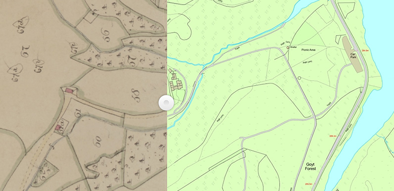
Above: The 1845 tithe map on the left reveals that Errwood Hall hadn’t been built at the time it was drawn.

Above: Clicking on plot 58 reveals that Samuel Grimshawe owned the land. (Samuel added the ‘e’ at the end of his surname some years later.)
I came across a wonderful resource called ‘Cheshire Tithe Maps Online‘ a few years ago when researching Stonyway Toll Bar, which once stood at the junction of the old and new Buxton to Macclesfield turnpikes, just beyond the Cat & Fiddle (click to view post). But I must admit that I never thought to check what it revealed about Errwood Hall.
Chris on the Goyt Valley Facebook Group was faster on the uptake than me, and has found that the 1845 tithe map shows that Samuel Grimshawe owned the land where the hall would sit, but that it hadn’t yet been built. Which surprised me as I’d always thought building work had started by the early 1840s (see timeline).
Above: Click the ‘Now’ button – or drag the green slider – to view an OS map from the late 1890s, some 50 years after the tithe map.
The 1845 tithe map shows that both Castedge Cottage and Shooters Clough Cottage were built before Errwood Hall. Which again surprised me as I’d always thought they formed part of the estate developed by the Grimshawe family after they’d moved into the hall.
Above: This fade shows Errwood Cottage, which once stood beside the gates of the entrance drive to the hall.
Unfortunately the Cheshire tithe map doesn’t show the larger part of Goyt’s Bridge to the east, including the packhorse bridge, as this was in Derbyshire – on the other side of the River Goyt which once formed the boundary between the two counties.
It’s interesting to see that Errwood Cottage was two separate buildings in 1845, and that one had been demolished by the time of the late 1890s map. There’s a similar fade on this page showing the difference in more detail, as well as the other buildings in Goyt’s Bridge.

The area was part of the huge Jodrell Estate, which encompassed all the collieries, farms, quarries before the extremely rich Grimshawes bought it from them – over a thousand acres. The Grimshawes enhanced the area structurally, with all the inhabitants becoming their tenants. The end of the Jodrell era was nigh by the time the Grimshawes bought the Upper Goyt Valley and in 1923, after the ravages of WW1, the entire estate, reaching as far as Furness Vale, was sold off.