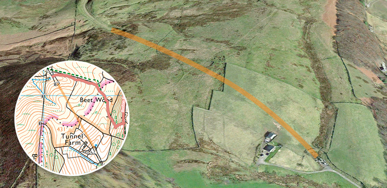
Above: A Google Earth satellite image of Tunnel Farm at bottom right. I’ve superimposed the orange line to show the route of the tunnel into the valley.
Many thanks to Mary on the Burbage Facebook Group for posting these two photos she found on ebay. They show the southern end of the tunnel on the Cromford and High Peak Railway being blocked off – probably in the early 1960s.


The tunnel was the longest on the 33-mile route which connected important canals in Cromford and Whaley Bridge. The line opened in 1831 and was a triumph of Victorian engineering.
The section through the tunnel into the Goyt Valley was closed in 1892 when an easier route via Buxton was opened which didn’t require wagons to be hauled up and down steep inclines. (Today’s main route into the valley from the Long Hill road was the longest incline on the track.)

Above: Patrick on the Goyt Valley Facebook Group posted this photo of the northern end of the tunnel showing the access door open and said he’d walked from one end to the other.
Asked how he managed it, Patrick explained: “…believe it or not, it was open. We walked to the end of the tunnel and as we walked back the workmen turned up and they said they’d forgotten to lock it. It was BT checking cables – good job we didn’t get locked in as it’s a fair way to the other end!”.
A number of walks on this website pass this end of the tunnel; 9 Buxton to Errwood), 10 (Old Goyt’s Lane), 12 (Cromford & High Peak Railway), 21 (Buxton to Goyt Valley) & 27 (Railway track short circular). There’s also one of Joe Brown’s Numbers carved nearby.
I’d love to see it reopened – like the tunnels on the Monsal Trail. But we’d first have to win our fight to have the track leading to the southern end made a public right of way (view details). And even then it would be very far from easy. I can’t see it happening – more’s the pity.

The was certainly still open until the late 1960s – I remember walking through it on a midnight hike so certainly no harder than walking over the top!
I was delighted to see this in my search for Tunnel Farm. I was born here in September 1944 when it was owned my grandparents Thomas and Margaret Bell. l returned to spend many memorable summer school holidays with my parents and siblings. Unfortunately I have misplaced the only photograph I had of the farm to show my own family and to add to my family history. I have tried unsuccessfully to print a copy of your photograph and wonder if you could possibly send me a copy.
I remember walking through the tunnel. It was locked at one end but the other end was still open. One thing that struck me was how narrow it was.
I certainly walked through it in 1965 when, during the school holidays, a group of us joined the Hanley to Buxton bus at various stops around Stockton Brook and Endon. We got off at Cistern’s Clough (in those days the road hadn’t been straightened and the stop was a regular getting off point for a walk), walked across the moor and went down the road to Fernilee Reservoir, where we crossed the reservoir via the old suspension bridge, and then followed the railway line back (passing through the tunnel) and descended to the junction of the A53/54, from where we caught the bus home.
The southern end was already boarded up around 1948/49. After Sunday school myself and maybe Doug Barler, climbed over the enclosing fence. My recollection of one of many boyhood adventures to be had when I lived in Burbage 1947 – 1950.
John Madelly, now living in Canberra.
Could someone help me to identify the ends of the tunnel please? I can see on google maps the one end that is marked and finding this for accuracy on what 3 words I can see it is at location – ///exclusive.shakes.pylon. Could someone give me an accurate location on the other entrance? Is it at – ///wonderfully.swims.outlawing? Anyone seriously interested in potentially trying to open this back up, create a cycling and walking loop from Derbyshire Bridge Car Park, please drop me a reply. Thank you.
Where is the PROW up to? because according to the Derbyshire planning website it was accepted from Macclesfield Old Road to Bishops Lane.