Christopher Saxton (1579)

Christopher Saxton (1579)

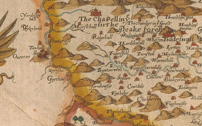
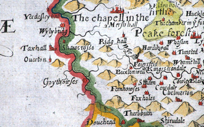
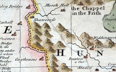
Above: This is the very first representation of Goyt’s Bridge – then known as Goythowses (Goyt Houses). Click the map below for a closer view. Above: Map of Derbyshire 1577 by Christopher Saxton (c1543 – c1610). © Devonshire Collection,...
William Hole (1607)

William Hole (1607)

Above: First issued in 1607, this image is copied from the 1637 edition of Camden’s Britannia. Above: Click the map to enlarge. Map courtesy of Copperplate Antique Maps. (Click to view a comprehensive stock of original antique county maps.) William Hole (1607)...
Jan Jansson (1646)

Jan Jansson (1646)

Above: First issued in 1646, this image is copied from Jan Jansson’s ‘Atlas Novus’. Above: Click the map to enlarge. Map courtesy of Copperplate Antique Maps. (Click to view a comprehensive stock of original antique county maps.) Jan Jansson (1646)...
Robert Morden (1695)

Robert Morden (1695)

Above: Click the map to enlarge. Map courtesy of Copperplate Antique Maps. (Click to view a comprehensive stock of original antique county maps.) Robert Morden (1695) By Kevin Welch of Copperplate Antique Maps. This Derbyshire map is by Robert Morden. Morden was...
Emanuel Bowen (1758)

Emanuel Bowen (1758)

Above: Click the map to enlarge. Map courtesy of Copperplate Antique Maps. (Click to view a comprehensive stock of original antique county maps.) Emanuel Bowen (1758) By Kevin Welch of Copperplate Antique Maps. This map is by Emanuel Bowen; one of the most prolific...
John Cary (1787)

John Cary (1787)

Above: First issued in 1787, these images are copied from the 1809 edition of John Cary’s ‘New and Correct English Atlas’. Maps courtesy of Copperplate Antique Maps. (Click to view a comprehensive stock of original antique county maps.) John Cary...
John Cary (c1801)

John Cary (c1801)

Above: Click either map (Cheshire top and Derbyshire above) to enlarge. Above: First issued in 1801, these images are copied from the 1811 edition of John Cary’s ‘New English Atlas’. John Cary (c1801) By Kevin Welch of Copperplate Antique Maps....
William Ebden (1824)

William Ebden (1824)

Above: Click map to enlarge. Maps courtesy of Copperplate Antique Maps. (Click to view a comprehensive stock of original antique county maps.) Above: First issued between 1824-8, this image is copied from W Ebden and J Duncans’ ‘A Complete County Atlas of...
T.L. Murray (1830)

T.L. Murray (1830)

Above: Click map to enlarge. Map courtesy of Copperplate Antique Maps. (Click to view a comprehensive stock of original antique county maps.) T.L. Murray (1830) By Kevin Welch of Copperplate Antique Maps. In 1830 Murray published ‘An Atlas of the English...