Maps courtesy of Copperplate Antique Maps. (Click to view a comprehensive stock of original antique county maps.)
John Cary (1787)
By Kevin Welch of Copperplate Antique Maps.
These two county maps of Cheshire and Derbyshire are by John Cary, and were first published in 1787 in his ‘New and Correct English Atlas’.
This atlas was a great commercial success and went through a large number of editions. It was so popular that after editions of 1787, 1793, 1795 and 1808, the copper plates had become so worn that new ones had to be engraved. Modified versions of Cary’s maps were still being issued by the publishers Gall and Inglis up to around 1900.
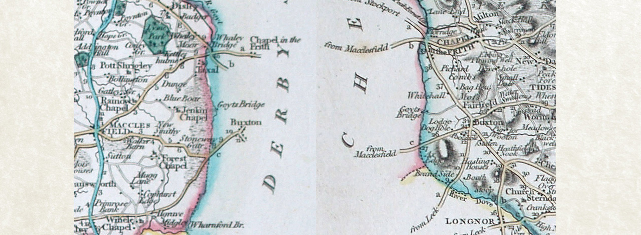
Cary avoided conducting any new surveys himself for these maps, preferring to base them on the most recent surveys produced by others. Cary’s first edition Derbyshire map was probably the first atlas map to show the name change from Goythouses to Goyts Bridge, which ties in well with the approximate date of 1762 we have for the construction of the packhorse bridge.
The name Goyts Bridge did not, however, appear on the same edition of the Cheshire map. This was probably a simple omission which was later corrected, at least by the time of the 1809 edition from which the two images above are taken.
Cary’s New and Correct Atlas was also groundbreaking in showing more minor roads than earlier atlases. Taken together, the two maps of Cheshire and Derbyshire are probably the first atlas maps to show the minor road from Jenkin Chapel crossing the river at Goyt’s Bridge and continuing to join the main road from Buxton to Whaley Bridge.
(Apologies that the images are not great for resolution, as they are crops taken from old photos. The actual maps were sold some time ago.)
Next: John Cary (c1801) | Previous: Emanuel Bowen (1758) | All maps