Walk 1: Riverside path > Packhorse bridgeWalk stats Length: 2.3mls | Av. time: 1hr | Ascent: 179ftStart: Errwood Hall car park | Google MapWalk description, map & GPX: More details Walk description Starting from Errwood Hall car park, opposite Errwood...
Topic tags: Projects...
1-riverside-packhorse-bridge-OLD
Walk 1: Riverside path > Packhorse bridge Length: 2.3mls | Av. time: 1hr | Ascent: 179ftStart: Errwood Hall car park | Google MapRoute description & GPX: Download options Walk description Starting from Errwood Hall car park, opposite Errwood Reservoir, this...
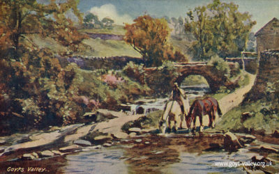
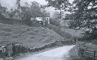
Goyt’s Bridge
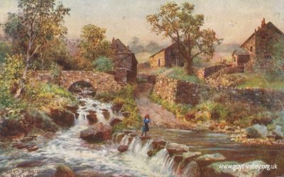
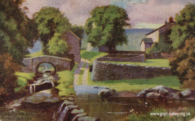
Goyt's Bridge A collection of general views of Goyt's Bridge; the small hamlet that now lies submerged at the southern end of Errwood Reservoir. Simply click on any image to enlarge and view captions, and then scroll through the collection. And click here for more...
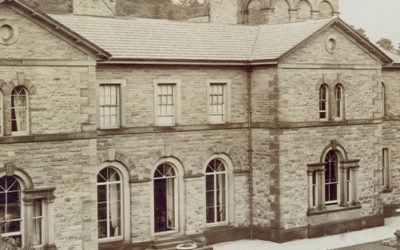
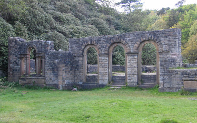
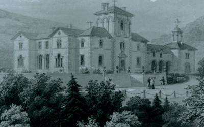
Errwood Hall & garden
Errwood Hall & groundsThese photos show Errwood Hall and its grounds in all their former glory. The Grimshawe family's grand country house was built in the early 1840s and demolished less than 100 years later. Click on any image to...
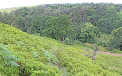
Goyt Valley views
Goyt Valley views A collection of general views taken throughout the valley, from as far south as Derbyshire Bridge, close to the source of the River Goyt, through to Taxal in the north. Click any image to enlarge and view captions, and then scroll through the photos....
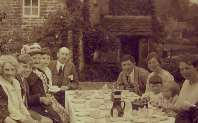
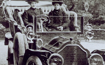
Grimshawe family & friends
Grimshawe family & friendsSamuel Grimshawe, a wealthy Manchester industrialist, purchased the Errwood Estate in 1832, from John Jodrell. We think construction work on Errwood Hall started in 1840, overseen by his son, also called Samuel. The family...
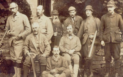
Estate families & workers
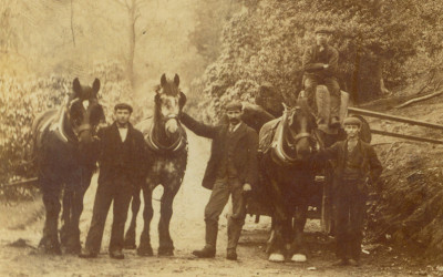
Errwood Estate families and workersThe photo above showing Errwood Estate gamekeepers and workers outside the gates leading to Errwood Hall is one of the the oldest in the collection, dated 1880. Click on any image to enlarge and view what information I...
Lost farmhouses
Lost Goyt Valley farmhouses When Samuel Grimshawe purchased the Errwood Estate in 1832 it included some 20 working farms. Most of the families had worked this land for generations. But when Mary, the last of there Grimshawes, died in 1930, and Stockport...
1930 record
The Goyt Valley, 1930My thanks to Gail for discovering these fairly poor quality images which I think must have been taken in 1930 as a record of the valley before construction work started on Fernilee Reservoir. Simply click on any image to enlarge and...
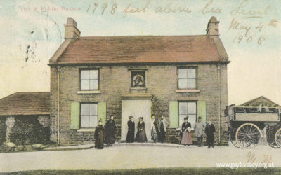
Cat & Fiddle Inn
The Cat & Fiddle Inn Standing close to the source of the River Goyt, this famous pub (once reputed to be the highest in England, but now designated the second highest!) was on the edge of the Grimshawe's Errwood Estate. The postcards include many...
Michael’s postcards
Michael's Goyt Valley postcards My thanks to Michael Baines for kindly allowing me to scan some of his wonderful collection of Goyt Valley postcards. Many of his cards are already featured on the website, so I've only included those that don't appear on...
Cat & Fiddle postcards
The Cat & Fiddle Pub Many thanks to Corrie for allowing me to scan her collection of old postcards showing the famous Cat & Fiddle pub. Standing close to the source of the River Goyt, it was on the edge of the Grimshawe's Errwood Estate. The...
Corrie’s postcards
Corrie's postcards All the postcards shown here were kindly sent to me by Corrie. They feature the drowned hamlet of Goyt's Bridge, as well as the Goyt all the way from Derbyshire Bridge to Taxal. Click on any image to...
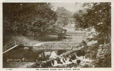
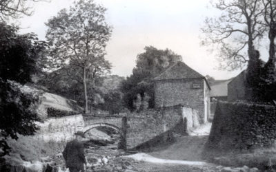
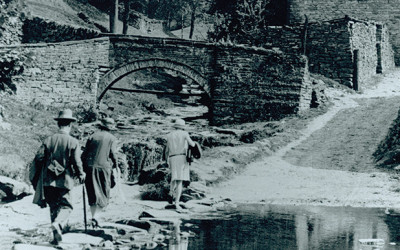
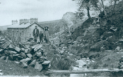
The stepping stones
Above: I've highlighted the camera view in green. The photographer was standing beside the small packhorse bridge, alongside Wildmoorestone Brook as it joins the River Goyt. Goytshead Farm is just behind. The stepping stones #1 Many thanks to Mike for...
Walk maps
Goyt Valley walks maps I created these maps to fill the screen of a typical smart phone, which is why north points in different directions. Click any heading to view detailed step-by-step directions and photos, plus a short 'Relive' video. And...
Goyt’s Bridge
Goyt's Bridge views A collection of general views of Goyt's Bridge; the small hamlet which now lies submerged at the southern end of Errwood Reservoir. Simply click on any image to enlarge, and then scroll through the collection using the arrow keys on your...
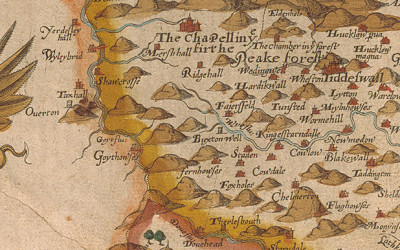
Christopher Saxton (1579)
Above: This is the very first representation of Goyt's Bridge - then known as Goythowses (Goyt Houses). Click the map below for a closer view. Above: Map of Derbyshire 1577 by Christopher Saxton (c1543 - c1610). © Devonshire Collection, Chatsworth. Reproduced by...
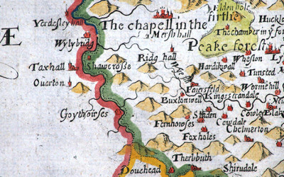
William Hole (1607)
Above: First issued in 1607, this image is copied from the 1637 edition of Camden's Britannia. Above: Click the map to enlarge. Map courtesy of Copperplate Antique Maps. (Click to view a comprehensive stock of original antique county maps.) William Hole (1607)...
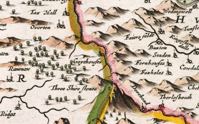
Jan Jansson (1646)
Above: First issued in 1646, this image is copied from Jan Jansson's 'Atlas Novus'. Above: Click the map to enlarge. Map courtesy of Copperplate Antique Maps. (Click to view a comprehensive stock of original antique county maps.) Jan Jansson (1646) By Kevin Welch of...
Goyt views
Goyt Valley views General views around the Goyt Valley, including some of the outlying farms and houses, many of which now lie submerged beneath the the twin reservoirs. Simply click on any image to enlarge, and then scroll through the collection using...
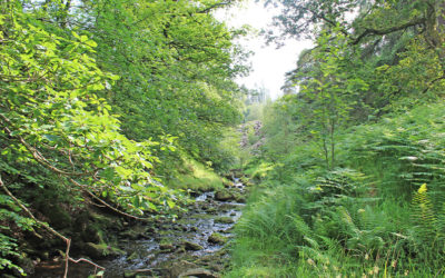
1. Riverside Walk
except goes here
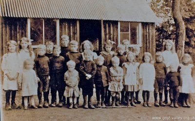
Goyt folk
Goyt Valley folkPhotos of some of the people who lived and worked in the Goyt Valley before the the construction of the twin reservoirs. Ranging from the Grimshawes of Errwood Hall and their friends and servants, to farm workers and their families. Simply...
2. Errwood Hall & the Graves
Excerpt goes here…
3. Valley Views
A detailed, step-by-step description and map of this walk are available to download for just £1.85. A walking app GPX file is also available at £1.50. Save on both for just £2.95. All proceeds help cover the hosting costs of this website.Walk description... Length:...
Errwood Hall
Errwood Hall & Grounds These photos show Errwood Hall and its grounds in all their former glory. The Grimshawe family's grand country house was built in the early 1840s and demolished less than 100 years later. Click on any image to enlarge, and then scroll...
4: Hall & shrine OLD
Goyt Valley walk 4: Errwood Hall & The Shrine Walk distance: 3 miles | Date recorded: July 2019Start point: Errwood Hall car park | Google MapGPX file: Just £1.50 | Download file This easy, three-mile walk takes in three of the most historic sites in this part of...
The Grimshawes
The Grimshawe family & friends The Grimshawe family of Errwood Hall moved in very grand circles, counting the Spanish royal family amongst their friends. I haven't yet managed to identify all the faces on this page. Click on any image to enlarge, and then...
4. Errwood Hall & the Shrine
A detailed, step-by-step description and map of this walk are available to download for just £1.85. A walking app GPX file is also available at £1.50. Save on both for just £2.95. All proceeds help cover the hosting costs of this website.Walk description... Length:...
5. Whaley Bridge to Taxal
A detailed, step-by-step description and map of this walk are available to download for just £1.85. A walking app GPX file is also available at £1.50. Save on both for just £2.95. All proceeds help cover the hosting costs of this website.Walk description... Length:...
Estate workers
Errwood Hall staff & servants The Grimshawes of Errwood Hall employed a large staff of servants and estate workers. They were the principal employers in this upper part of the Goyt Valley. Simply click on any photo to enlarge, and then scroll through the...