Above: Known as ‘the human fly’, Joe was acknowledged as one of Britain’s finest mountaineers.
He carved orienteering clues into rocks at 20 locations around the valley. The one above right is on the back of the shrine beside the lane leading down to the twin reservoirs.
I hadn’t heard of ‘Joe Brown’s numbers’ until a few days ago when someone I met mentioned them. I asked on the Goyt Valley Facebook group whether anyone else knew about them, and was soon able to discover the story.
Joe died last year, but in his time was acknowledged as one of Britain’s finest rock climbers. Someone on his Wikipedia page says “he’s regarded by many as the finest British climber of the twentieth century”. I can well remember watching his terrifying ascent up Orkney’s ‘Old Man of Hoy’ live on BBC in 1967.
During the early ’60s Joe worked at White Hall Outdoor Centre, just outside Buxton. And it was during this time that he created an orienteering course in and around the Goyt Valley.
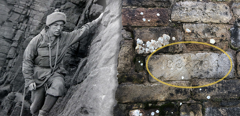
According to this website, the course is around 17 miles long and comprises 20 clues, each a series of numbers about two inches high, chiselled into stone.

Peter on the GV FB group explained:
“The first number is carved onto the gatepost at the back of the White Hall Centre (above). It points to clue 2. Clue 2 points to clue 3 and so on. The numbers are all either a grid reference, or a compass bearing and a distance to the next clue.
“It’s probably worth chopping up your hunt into 3 or 4 chunks as finding the clues typically takes longer than getting to the next one. There’s a bottle of 12 year old single malt just by the last clue for people to have a wee dram to celebrate the bog hopping back to the start!”
Reading descriptions of the course, it does look fairly challenging. Some of the clues seem very hard to find, and also badly weathered, making them difficult to decipher.
Easing the challenge
I take my hat off to anyone who manages to complete the course using the clues Joe carved. For the rest of us, I’ve posted descriptions of a southern route of just over eight miles, and a more strenuous northern version of 11 miles, both starting from The Street car park. Click either link to view.
I’ve also created a crib sheet showing Joe’s numbers, with corresponding What3Words co-ordinates. I’m not sure Joe would have approved, and many orienteering purists may object, but the clues are quite difficult to find, even using the crib sheet. And both walks make enjoyable challenges exploring a wonderful landscape, so I hope I’ll be excused!
There’s also to a geocache version of the challenge (click to view). I’ve never tried geocaching, but would love to know how it works. If anyone has tried using it to follow Joe’s course, please get in touch, or leave a comment below.
GPX files
Page update: GPX files for two halves of the route are now available from this website at just £1 each. Click here to download the easier, southern route gpx file. And here for the more strenuous northern section.
Page update 21.1.25: Congratulations to Darren for completing the challenge (see his comments below). But a great shame that the final clue – no.20 – seems to have vanished. His YouTube video is well worth a view, showing just how difficult it is to complete in a single day.
Page update: 22.3.25: Clue 20 is still there – and fairly easy to spot. But the original stone must have been lost as there’s now just a small metal plate screwed near the base of one of the corner quoins.


Page update: 27.3.25: These are the numbers found by Liam Corner – see comment below. Above left is the set at Shining Tor that point towards Cats Tor. And above right is the set at the old railway bridge near the foot of the Bunsall Incline which point towards Errwood Bridge in the centre of Goyt’s Bridge.
Page update: 29.3.25: Click here to read more about the inscribed stone found by Liam beside the bridge at the bottom of the Bunsall Incline.

I met Joe Brown a couple of times when I was a child, in the 1950s. His brother and his family lived next door and his niece was my best friend (we are still in touch though our lives have led us to different locations). He was hero to my young uncles who would spend most of their days off cycling or catching the train to open country to go rock climbing or potholing. Like Joe, they had to work for a living and didn’t have the private income that would enable them to buy expensive equipment or spend huge chunks of time in the Alps or climbing Everest. We loved to watch him on TV and although I never climbed he was part of the inspiration for my love of walking and hiking.
We completed Joe’s challenge earlier in February. We started at Whitehall doing a few each day! One of the carved numbers is not there because of damage but there is a plaque! After we finished we did the geocache using Joe’s grid references and found and signed the notebook.
We started at the shrine today and found the next 9 clues. We did need the clue from the Macclesfield Harriers site to find the number which has a corrected location. It was a lot of fun and we look forward to looking for the rest!
I completed the numbers trail in July 2017 with the help of the geocache information. I did it as circular walks over two days 1 – 11 on day 1 and 12-20 on day 2 and managed to find them all. It was an excellent expedition.
I have previously done the Geocache version, but today decided to have a go at the original. Got stuck at number 3 (where the stream runs into the culvert), spent about an hour looking but no find. Any clues would be welcome.
Thanks for this. I took my binoculars up stream a bit to check all the stones that make up the culvert, but still couldn’t find it. As I’m looking down stream is is to the left, middle or right. I returned to try to find a few more today, but out of 6 locations only managed to find 2. Do you know which ones are missing if any please?
I completed the challenge in a day for the geocache a couple of years ago, although I’ll admit to using the detailed clue sheet to help me find the exact locations. But I have since come across a couple of additional numbers which are not part of the 20 locations in the challenge which made me wonder if there is a second challenge out there somewhere?
The first set of numbers are on the rocks at Shining Tor (SJ994737) and read 995759. This looks like it points to Cats Tor, probably the wall. I’ve searched what remains of the walls there (although only the eastern face) but failed to spot any more numbers.
The second set are on the NW face of the old bridge at the NW end of Bunsal Cob car park (SK 0178 7590). They read 202×970, ie bearing and distance. I’ve plotted these to the middle of Errwood Reservoir, but when overlaid on an old map it seems to point to Errwood Bridge in Goyt’s Bridge (SK 0145 7507). Sadly we’ll never be able to check that out now so any route is broken here.
I’d love to know if anybody knows anything about these additional numbers or has found any more?