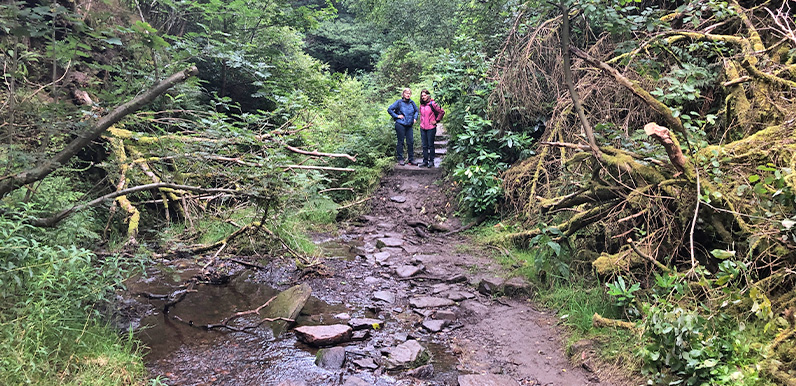
Above: These two ladies kindly allowed me to take their photo as they pondered how best to cross the stream. It was very muddy and slippery and both were nervous about tackling the slope and then finding a way across the stones.
I first noticed that the attractive footbridge behind the ruins of Errwood Hall had vanished about a week ago. But I’ve been unable to discover who removed it, and why.
I assumed it must have been the owners of the land; United Utilities. But Callum on the Goyt Valley Facebook Group believes it was Forestry England which manages this part of the estate. He used to work for FE and suggested I contact them.
Above: Press the ‘Now’ button, or drag the slider, to see the difference. The before photo was taken some years ago (hence the change in vegetation), but the footbridge looked fine when I last used it a month or so ago.
It’s now mid August and the mud is already making it difficult to cross the stream. It will be a lot worse in winter, which is why I’m hoping that it will be replaced as soon as possible. But although I followed Callum’s advice and emailed three contacts I know at FE, I haven’t had any response to my questions about why it was removed and whether it will be replaced.

Above: I’ve circled the bridge over the stream on this map from the 1890s, showing there was one in the same position during the time of the Grimshawes (click to enlarge).

Above: The two friends were on their way to visit the hill-top graveyard of the Grimshawes who once lived at Errwood Hall.
The path running around the ruins is one of the most popular in the valley, and features on many of the walks described on this website. So I’m wondering whether to put a warning in the descriptions about the possible difficulty in going this way. I do think that FE – if they are responsible for removing the bridge – owe us an explanation.
My concern is that FE has recently examined the bridge and found areas in need of repair – which would be understandable given the amount of wear it’s had over the years. But rather than pay for the work, FE decided that a far easier and cheaper option was to simply remove it and leave visitors with the choice of whether to risk it or not.
But until I get a response from FE, this is all guesswork on my part. So I’ll update this page if I manage to discover any more. I’ll also try to contact the Peak District National Park as I think they have some responsibility for public access within the valley.


Building the bridge
Page update: Many thanks to Andy on the Goyt Valley Facebook Group for posting these photos showing before, during and after he built the bridge back in January 2002.
He says that he charged £678 for the work (which included the nearby smaller bridge), and that it was joint-funded by FC, UU and PDNP, adding that he knew it would need repairing or replacing in around 20 years.
I’ve asked Andy if he has any idea how much it would cost to replace today. Some people have suggested that it would be too expensive. But I’d be interested to see how it compares to the cost of the ugly barrier fencing that was recently installed along the metal road bridge. I’d guess it would be a small fraction. I’d also suggest that it would be a tiny drop in the vast ocean of UU’s £450 million profit for last year.
You also have to wonder how many people might be injured trying to cross the stream now that the bridge has been removed, compared to how many have fallen off the metal bridge. But perhaps I’m rushing to judgement. And UU, FE and PDNP already have plans in hand to rebuild the bridge. Here’s hoping…
Forestry England responds
Page update: 2nd September 2023: I’ve had a response from Chris at Forestry England regarding the lost bridge. Unfortunately it doesn’t sound like good news…
The bridge/boardwalk that you have contacted us about has been removed following an inspection by our Civil Engineer highlighted a number of safety concerns. Whilst this is disappointing, I am sure you understand that the safety of our visitors, local communities and our staff is our number one priority.
We are currently reviewing the options for this location but are having to carefully balance the costs and resource implications against a number of other priorities across the valley. This includes tree safety works, and trying to keep up with the results of anti-social behaviour – which is proving a huge drain on our resources at the moment.
We are also aware that we may have to close the path that leads down to the stream from the side of the hall. This is not due to the bridge removal, but is due to the trees along there being diseased and therefore posing a potential safety risk.
Removing these trees is not only going to be costly and time consuming, but there are the implications to wildlife habitats and the potential for landslip (as we believe the tree roots may be supporting the hillside at the moment) which means this work needs to be carefully considered by our various civil engineering and ecology teams before any work can be commissioned.
So it sounds like FE plan to close the footpath around the back of the ruins. I’ve asked Chris when they’re likely to make a decision, and whether FE could extend the steps to the stream in the meantime, and also place some stepping stones across the water to make it easier to cross. I’ll update this page if I get a reply.

Path now closed
Page update: 15th September 2023: Forestry England has now put up ‘route closed’ signs at both ends of the footpath around the back of Errwood Hall ruins. The notice reads ‘The boardwalk has been removed because it has been assessed by our engineers and found to be unsafe’.
Personally I think it’s a complete over-reaction on behalf of FE, and that it would have been far better to simply repair suspect areas, or replace the complete structure. I also think the excuse about the risk posed by diseased trees is completely spurious.
I ignored the signs and crossed the stream fairly easily over some of the large stones. But I can’t advise anyone else to do the same. So I’ve had to alter the descriptions on walks 2, 8, 15, 26 & 28 which go this way.

I wondered whether I’d imagined there was a bridge here as there were no signs of it ever existing and no notices warning of removal. I googled it tonight and found this page it as I was so unsure! Not easy crossing the stream with a small child and a baby in a baby carrier without the bridge :-/