Click any image to enlarge.
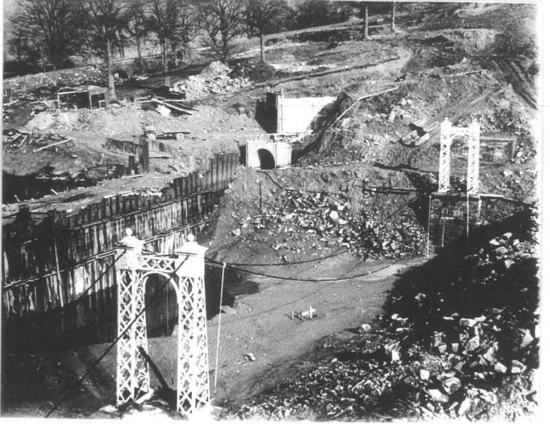
Above: This photo shows the suspension bridge being dismantled during the construction of Errwood Reservoir in the mid 1960s.
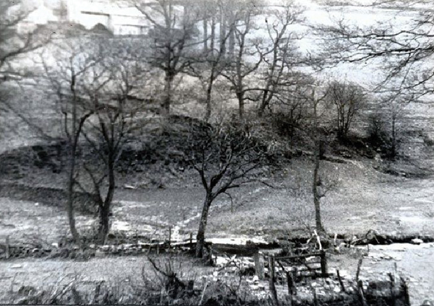
From RS-S: This is quite an interesting old photograph taken before the flooding of the Valley. It shows the ford below Bunsall Farm, which you can just make out at the top of the picture. The suspension bridge was later constructed at this point – and it was this crossing that determined the position of the bridge.
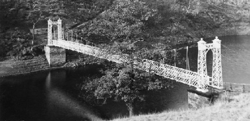
I’ve always been curious about the small but very picturesque suspension bridge that can be seen in various old photos of the valley, wondering when it was built, what happened to it, and where it was situated.
It was a comment in the Memories of Crichton Porteus posted last week which seemed to answer some of these questions;
Near the head of the reservoir a steel suspension bridge, connecting as it seems no special place to anywhere else, spans the water, offering a good view northward of the wider end of the reservoir. Erected in 1935 at a cost of well over £500, this bridge is scarcely used in the week.
So it seems the bridge was created just before the completion of Fernilee Reservoir. And since it was very much a pedestrian-only bridge, it must have been to provide easy access for local people to walk from one side of the valley to the other once the valley had been flooded.
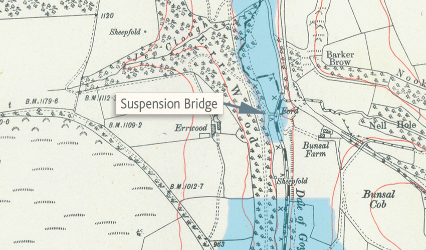
Click the map to enlarge it. The blue areas show the position of today’s twin reservoirs.
Replacing the ford
Looking more carefully at the old photos, it’s clear that it spanned the southern part of Fernilee Reservoir – close to the foot of the present-day dam wall which divides the twin reservoirs.
Examining an old OS map (see above), reveals there was once a ford around this point across the Goyt, leading from behind Bunsal Farm all the way to the old Roman road known as The Street. The footpath on the opposite side of the valley – which can be seen in the top photo – can also be identified on the map.
So the suspension bridge must have reconnected both sides of the existing right-of-way footpath after the valley had been flooded. Sherlock would have been proud of me! But I’m still not sure when it was demolished. I’m guessing it must have been during the final stages of the construction of Errwood Reservoir – so some time during the mid-1960s.
I have heard that it’s possible to find some evidence of the bridge foundations. I’ll have to have a closer look next time I get the opportunity. In the meantime, if anyone has any more old photos, or can remember the bridge and knows when it was destroyed, please leave a comment below, or get in touch using the contact form.
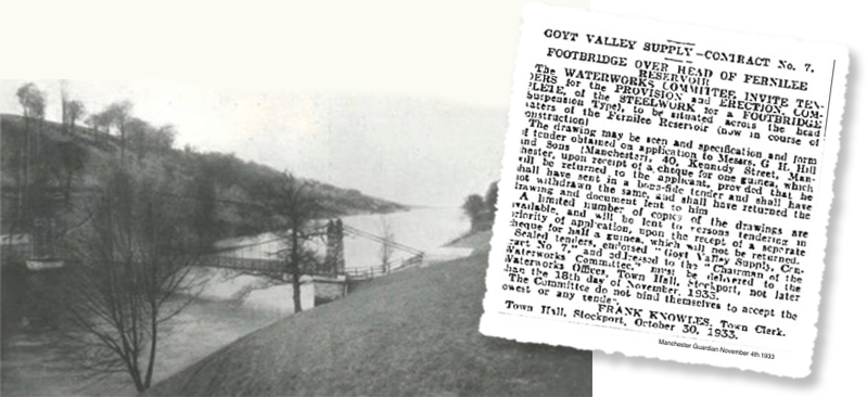
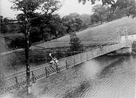
Page update: My thanks to Gail for sending this photo of the suspension bridge taken in 1937, and a copy of the original tender document for its construction dated 1933 (click to enlarge).
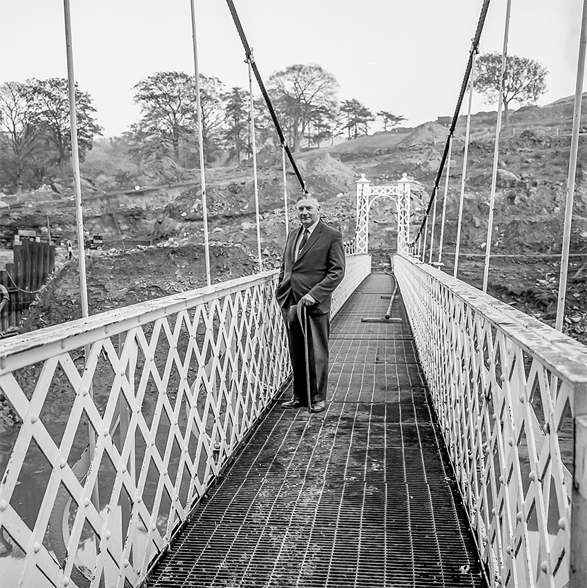
Page update 16.4.19: My thanks to Dickie (see comment below) for sending this wonderful photo of his father standing on the suspension bridge (click to enlarge).
It was taken shortly before it was dismantled, during the construction of Errwood Reservoir to the north. (The building work can be seen in the background.)

Page update 12.9.24: Many thanks to John on the Furness Vale History Facebook page for allowing me to post his photo showing the suspension bridge shortly before it was dismantled with shuttering piles being driven into Fernilee Reservoir to hold the water back.


Page update 9.10.24: Many thanks to John Bingham on the Goyt Valley Facebook Group for posting these two photos he discovered in a box at his local library showing the suspension bridge (click to enlarge). Chris Simpson recognised himself on the first photo, standing between friends, John and Janet Eastwood, and says it was taken by his grandfather.

The Grimshawes of Errwood Hall knew they would one day lose their home. One thing they did before the land under the reservoirs was compulsory purchased was to insert a covenant in the deeds that said there must remain an access over the valley when Fernilee Reservoir was built.
Obviously, as the valley would be under water, this was not a possibility, but Stockport Corporation came up with a plan of a footbridge at the top end of Fernilee – because the reservoir would be at its narrowest there.
When Errwood Dam was almost in place it formed a new access over the valley thus making Grimshawe’s restrictive covenant void and so the suspension bridge was taken down and scrapped.
Wonderful information; another example of what kind and philanthropic folk the Grimshaws were.
Hi David, fantastic Web site, really great source of information for a place I’ve always been fascinated by and walked round many times. Looking at the photos here and the old map, I suspect that the suspension bridge was closer to where the Errwood dam wall is now. I’m looking at the lay of the land behind the bridge and the distance to the bend in the Bunsal incline and it looks like it’s closer to where the track from Bunsal farm enters what is now the reservoir rather than down where the original ford was. This would probably mean that all trace of the bridges footings would have gone as the dam wall was completed. I may of course be complete wrong!
I have a photograph I took of my father on the old suspension bridge shortly before it was demolished that I can send you. Unfortunately there’s no date marked on the back. My best bet would be about 1965 (as I believe Errwood Reservoir was finished in 1967).
My father, who had no connection with the works, died in 1981. We spent many happy hours in the area, latterly with my late wife (as teenagers), and these visits were prompted by my interest in the C&HPR.
I remember walking over this bridge as a child with my parents for years. I wondered what became of it, and even thought I must have been mistaken. One day much, much later, when walking the dog alongside Fernilee in the woods, I came across a large concrete pad which I think was one of the anchor points for the suspension cables. This made me sure I had not been mistaken, though not knowing until now that the bridge had been dismantled, I spent many pointless hours as a teenager looking for it. What a shame it was never rebuilt. Happy childhood memories.
From looking at the old maps, I wonder if the suspension bridge was located a little to the S of the ford shown on the 1892 – 1914 map (click to view). The 1937 – 1961 map shows a footbridge where the earthen bank of Errwood Reservoir dam is now (click to view).
I walked over the bridge many times before it was removed. The main overhead cables were coated in some sort of grease that never seemed to melt.