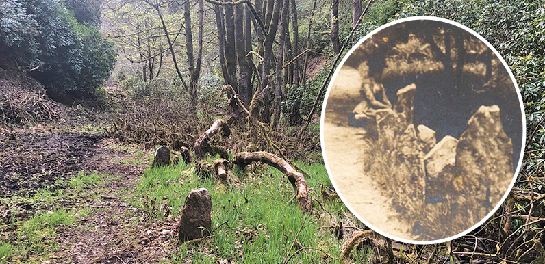
Above: The recent clearance of the drive has revealed a series of upright stones bordering Shooters’ Clough. The early 1900s postcard below shows a lady sat between some of those same stones.
At the time of writing, in early June 2025, the water level in Errwood Reservoir has dropped dramatically following some gloriously sunny and dry spring weather. And it’s coincided with some work Forestry England has been doing to clear the undergrowth beside Shooters’ Clough – the stream that runs along the old drive that once linked the hamlet of Goyt’s Bridge with Errwood Hall.
This has meant that it’s recently been possible to walk a good distance along the drive, from the ruins of the hall all the way to where it vanishes into the waters of the reservoir beneath the modern road bridge. And it’s revealed an intriguing series of upright stones that once bordered the lane.

Above: A postcard dating back to the early 1900s – if not earlier – showing the lane leading up to Errwood Hall. Look closely to spot the lady in the centre (inset above).
The postcard also shows some of the many rhododendrons the Grimshawes planted around their estate. And it’s these shrubs – brought back as ballast in the family’s ocean-going yacht – that Forestry England have been clearing to halt the spread of a disease carried by rhododendrons that destroys trees such as commercially-grown larch.

Above: The remains of the stone bridge that once carried the lane from one side of Shooters’ Clough to the other are also visible as you approach the supports of the modern bridge.
Above: The orange circle on this map from the early 1900s shows where the postcard photograph was taken, looking along the drive towards Errwood Hall. I’ve also highlighted the position of the old bridge. Click the Now button – or drag the green slider – to see today’s satellite view, with Errwood Reservoir at far right.
