Goyt Valley walk 24: Fernilee to Castle Naze

Walk distance: 12 miles | Date recorded: April 2020
Start point: Bunsall Inline car park (SK17 6GJ) | Google Map
Map app: View on OutdoorActive | Contact me for GPX file

Above: Click map to enlarge.
View printable A4 pdf.

Above: A ‘Relive’ version of the walk. Click to play and use the expand option to view in full-screen. Click here for more Goyt Valley ‘Relives’.

Walk description & directions

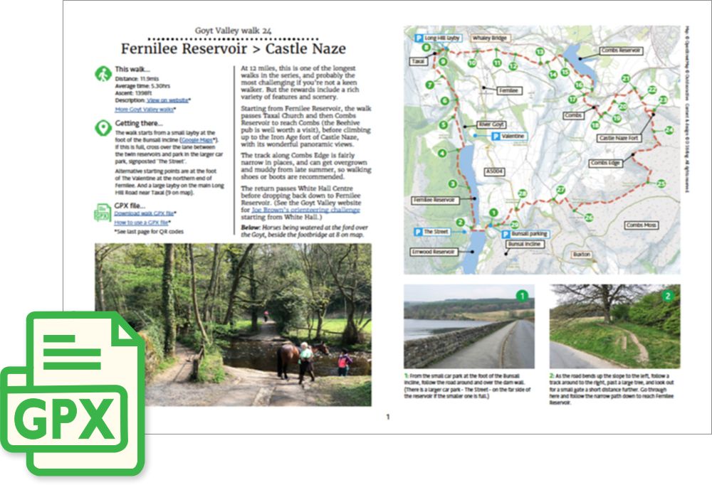
At 12 miles, this is one of the longest walks in the series, and probably the most challenging if you’re not a keen walker. But the rewards include a rich variety of features and scenery. Starting from Fernilee Reservoir, the walk passes Taxal Church and then Combs Reservoir before climbing up to the ancient Iron Age fort of Castle Naze, with its breath-taking panoramic views, and returning via Combs Edge.

Because it is a fairly long walk, it’s not easy to describe it within my maximum 29 stages. So I’d recommend marking the route on an OS map. And maybe downloading the walk using the ViewRanger app to follow it on your smartphone (with a portable battery charger in case it runs out of power).

1: The walk starts from the small carpark at the foot of the Bunsall Incline – the long straight road that slopes steeply down from the Buxton to Whaley Bridge road. From here, follow the road around and over the dam wall. (There is a larger carpark on this side of the reservoir if the smaller one is full.)

2: As the road bends up the slope to the left, follow a track around to the right, past a large tree, and look out for a small gate a short distance further. Go through here and follow the narrow path down to reach Fernilee Reservoir.

3: Turn left along the wide track beside the reservoir. There are some wonderful views across the reservoir from this path. The reservoir was flooded in 1937. Under the northern end lie the ruins of Fernilee Gunpowder Mill.

4: The path eventually rises up some steps. Turn right when you reach the top, and follow it until you exit the woodland through a wooden gate, turning right along the narrow road to reach the far end of the reservoir.

5: As you reach the reservoir, keep in the same direction along a farm track, crossing a cattle grid. After about half a mile, look out for a small wooden gate, down the slope to your right, just before you reach Knipe Farm. Go though here and head diagonally left across the fields, passing through a wider farm gate.

6: The path winds down to a stile beside a narrow bridge over the Goyt. This shows how the valley would have looked before the construction of the twin reservoirs. Turn left before the bridge, and follow the path up through Hillbridge Wood Nature Reserve.

7: Exit the woodland through a small gate and keep in the same direction, following the fairly indistinct path across the field to the far left corner. Turn right at the narrow road and then right again just before Taxal Church. The church is well worth a visit, although it’s usually locked.

8: Cross the narrow footbridge to the left of the ford, turning right and then immediately left up the slope. Follow this track as it winds up to the main Buxton to Whaley Bridge road.

9: Turn left to the end of the lay-by, and cross the road, heading up a farm track. Continue in the same direction when you reach the narrow road, past Shallcross Hall and through the small housing estate. (A display board on the left explains the history of the Shallcross Incline.)

10: As you exit the estate, cross the road straight ahead. Go past some buildings, and then follow the farm track through a gate to open fields, keeping to the left of the fencing and stone walling.

11: At the end of the track, go through a wide metal gate, and keep in the same direction, over a stile in the stone wall opposite. From here, keep the wall on your right for some distance until the track drops down to another gate and a junction of paths.

12: Take the wider track that leads diagonally left up the slope. Follow this for some distance until you exit through a small gate in the stone wall. Continue in the same direction as the path becomes more indistinct, eventually reaching open fields. Keep to the left of the trees up the slope, and then some farm fencing as the ground starts to level off.

13: At the end of the fields go over a stile and follow the farm track straight ahead. Pass through a gate leading into a farmyard, following it as it winds first to the left and then the right.

14: Follow the narrow lane around to the right, eventually passing over the railway bridge, and you soon come to Combs Reservoir on your right.

15: Turn right along the concrete path which runs beside the reservoir, until you exit through a small wooden gate. Follow the fairly indistinct path across the fields until you can cross the stream on your right over a small footbridge.

16: Follow the track across the fields until you reach a wooden gate, just before a railway bridge

17: Turn left under the railway bridge, then through a small wooden gate, and left along the road, to reach Combs. Go past the Beehive pub, which is well worth a visit, continuing in the same direction along the road until you come to a footpath sign on your left.

18: Head towards the house at the end of the drive, and then turn right, between this house and a stone building.

19: Go through two small wooden gates and head diagonally left up the slope, and then follow the fairly indistinct path to the right of the trees for some distance, eventually exiting over a small wooden stile. 

20: Keep in the same direction across the field, going through a wide gap in the wire fencing, and then over one stile on the right, and another stile diagonally right, heading towards a wide track that slopes up on the right.

21: Follow the wide track up the slope as it winds around to the left, passing through a field gate. Head up this path for some distance until you exit through a smaller gate. Go to the end of this field and turn right up the slope to exit over a wooden stile.

22: Turn right up the lane, keeping to the right, until you can walk between two buildings, and follow the wide track up the slope. You can see Castle Naze high up on the horizon. But the climb isn’t as bad as it may look from here!

23: Follow the wide track up the slope, going over the gate on the right, and keeping the stone wall on your left. Cross two stiles either side of the lane and follow the path up the slope to reach Castle Naze. Turn left at the summit and cross a stile to explore the old Iron Age fort. But it’s best to stick to the ramparts as the ground can be a bit treacherous.

24: There’s only one stile into the fort, so you have to exit at the same point and then follow the path around to the left, going past where you climbed up. Keep following this path for some distance. There is a path either side of the wall. The one to the right isn’t for those who don’t like heights. And the one on the left can get overgrown. But it’s easy to swap from one side to the other as there are lots of gaps in the wall.

25: Follow this narrow track for some distance, keeping the stone wall on your right. At one point the path winds down to a small footbridge, and then towards a small stone building on the right. The ridge is known as Combs Edge and offers some truly breath-taking views.

26: Eventually you will see White Hall Adventure Centre in the valley below. Head down the fairly steep slope, keeping the stone wall on your left, towards a gate in  the far left corner. Follow the path on the left towards a metal footpath sign, passing through another gate to reach the old Roman road.

27: Turn right along the old road, and then straight ahead at the cross-roads. Follow the next footpath sign beside a gate, keeping to the left of the wall, and head towards another small gate. Follow this path as it winds up to the summit, and then head down towards the main Long Hill road. You can now see Errwood Reservoir in the far distance.

28: Cross over the main Buxton to Whaley Bridge road through a couple of gates and follow the farm track as it winds around to the left. Follow the next footpath sign straight ahead when the track bends to the right, heading down the slope.

29: Cross the small footbridge at the foot of the slope and turn right, passing through woodland. This leads back to the small car park. Just before you exit the trees, look over to your right and you will see the tunnel through which trains on the Cromford & High Peak Railway once passed.