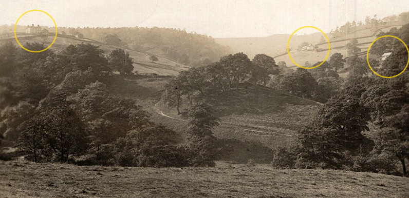
Above: I’ve circled the three farmhouses which helped pinpoint where the photographer would have been standing. Knipe Farm is hidden behind the trees in the centre.

Above: This is the full image. Click to expand.
Ebay is a wonderful source for old postcards showing the Goyt Valley before the construction of the twin reservoirs of Fernilee and Errwood. It’s usually fairly easy to work out where they were taken. But one that appeared last week proved a bit more of a puzzle.
The photo probably dates to the early 1900s. It was taken from above a slope and included three houses plus a narrow footpath that wound down from the opposite side of the valley.
Errwood and Intake farms?
My first thought was that the house to right of centre could have been Errwood Farm, where Samuel Grimshawe stayed during the construction of Errwood Hall. And that maybe the one further right could have been Intake. But I didn’t recognise the large building high on the far left horizon.
This is where the Goyt Valley Facebook Group comes into its own. There are now some 3,500 members and many of them have a far better understanding of the local landscape than me. So I posted the photo and asked whether anyone recognised the view.


Above from left: Normanwood, Oakend and Madscar farmhouses.
A number of people responded immediately, including Chris who looks after the FB Group and is usually first to work these things out. But it took a fair amount of head-scratching before Antony posted a message saying he recognised the house second from the left as he was born there…
That’s Oakend Farm – my birth place – with Madscar to the right and Normanwood to the left. I was told that Normanwood was demolished for materials for the pump house.
And if you look at some of the surviving farms – Oakend , Overton, etc., – they have blue slate roofs. This was because the Water Board also robbed the stone slates for the pump house as the original plan was to flood this valley and not Fernilee.

Above: I’ve plotted where I think the photographer was standing on this Google Earth satellite image by working back from the position of the three houses. The north end of Fernilee Reservoir is at the bottom of the image.
Normanwood was the only farmhouse north of Fernilee to have been demolished, presumably in the mid 1930s during the construction of the reservoir. (*Update: it was in the 1950s – see Bill’s comment below.) It looks a fine house from the grainy image, but there’s now only a few scattered outbuildings to show it ever existed.

Above: Normanwood today. Antony thinks it was demolished to provide stone for the pump house which once stood below the northern end of Fernilee Reservoir. (*Update: It was Disley Pump House – see Bill’s comment below.)
The lane winding down the slope in the centre of the photo leads from Knipe Farm which is hidden behind the trees. It runs down to the small metal footbridge that spans the River Goyt and must have been an ancient packhorse track. A number of walks on this website pass over the bridge. One of Joe Brown’s Numbers is also nearby.
Having identified the various buildings, it was fairly straight forward to work out where the photographer was standing; just below Folds Lane Farm which lies opposite the Shady Oak pub on the Long Hill road.

Further to the story of the farms, Bill Brocklehurst gives a snapshot of the area and life that makes interesting reading. Click to read.
Bill was born in 1943. His grandfather lived at Oldfield farm and had the grazing rights on 5,300 acres of high moorland around the Cat and Fiddle. As a child, Bill lived at Normanwood farm, then when his grandfather retired, the family moved into Oldfield farm. Both of these farms are situated in the upper Goyt valley. This is an extract from the Whaley Bridge History website…
Goyt Valley Roads Tracks and Trails: Extensive history of the Goyt Valley
Heading down the valley toward Fernilee the road climbed up past Errwood Farm, (The ruins are still visible to the left of Errwood Dam) crossing over Jep Clough via a small bridge made of tree trunks then past Stubbins Farm, Intake Farm and Masters Farm, at Masters Farm you could turn right past the Powder Mill and cross the valley up to Shawstile Farm, or carrying on at Masters Farm the road climbed up to Oldfield Farm then Normanwood Farm before dropping down to the Knipe (The road from the Knipe to Fernilee Dam is a private road constructed when the Reservoir was completed).
*Normanwood was pulled down and the stone was used to build a pump house on Jacksons Edge at Disley in the late ’50s. It was a very cold place to live in the winter months. I walked across the valley to Fernilee School every day for 4 years. In 1947 my dad got out of the bedroom window to feed the cows as the back door was buried under the snow for weeks! Happy times…