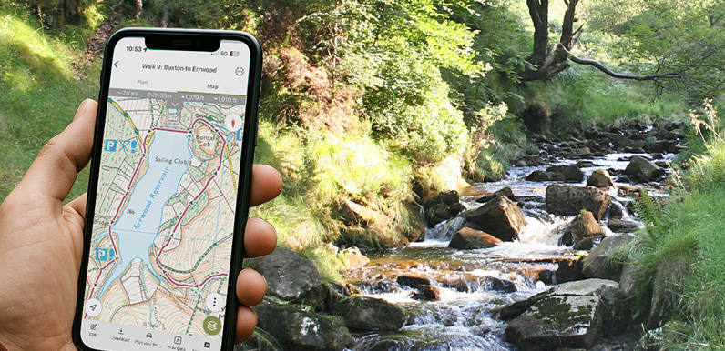
Above: Following the Buxton to Errwood Reservoir walk on OutdoorActive as it slopes down to the River Goyt.
An introduction to following a GPX route on a walking app, and some of the most popular apps available.
A detailed guide on how to upload and follow a GPX route using the OutdoorActive app.
View all the GPX files available on this website to follow any Goyt Valley walk.
I came across a couple of ladies walking the valley the other day who were complaining about the directions they were trying to follow. “We completely missed the path”, said one. “And now we’re not sure where we are. Can you help?”
It was then that I realised – and had to admit – that they were following one of my walks on their phone! The same thing happened a month or two back with a family who had only walked up from Errwood Hall car park. It made me realise just how easy it is to take a wrong turning, or misinterpret directions.
Using a walking app
I can’t remember the last time I tried to follow printed directions for a walk, or even an OS map. I always use a walking app on my phone where I can immediately see if I’ve taken a wrong turn, and where the path should be.
I’ve tried a few different walking apps over the years but now use OutdoorActive, which was once called ViewRanger. Other people swear by the OS app, or Strava, Komoot or AllTrails. They all offer both free and paid-for plans, and are very similar in the way they work. I’ve put links to all of them on this page.
There are now 30 walks on this website, in and around the Goyt Valley, varying in length from a couple of miles to over 12. And GPX files – which are used in all walking apps – are available for all of them at just £1.50 each. Which will go towards the ever-increasing costs of hosting and maintaining the website.

Above: Marie takes a break after coming down from Taxal Edge.
Marie was the first to purchase a GPX file – for the Taxal Edge walk. She and her husband, Paul, were visiting from Manchester. I asked how easy she found the process of buying and using the GPX file:
We had a day off work and fancied a hike in the Peak District. I Googled ‘walks in the Goyt Valley’ and came across your website. We found a walk we thought would suit us and noticed the link to purchase a GPX file.
It’s the first time I’ve used a GPX file. I also downloaded the free version of the OutdoorActive app. It was a very simple process – and I’m not known for my IT skills!
Your walk was great, but without the GPX tracking we would have gone wrong a few times – most noticeably on the far side of the ridge. It was the best £1.50 we have spent.
I’ve put links to the GPX files at the top of each walk description. And also listed all 30 of them here.

Just wanted to say thanks for the brilliant website. I did my first solo ‘hike’ today and did walk 8. It is in my top walks I’ve ever done. I downloaded the GPX too which meant I felt super relaxed navigating, along with your description and the photos it made for a really enjoyable day out. I’m so glad that people with passion like you go out of your way to create a way for more people to enjoy what you do! Thanks so much!